Address: 10900 (From 10900 To 10999) E (East) US HIGHWAY 36, AVON, IN 46123-7980, USA
What's 46123-7980? 46123-7980 is a ZIP Code 5 Plus 4 number of 10900 (From 10900 To 10999) E (East) US HIGHWAY 36, AVON, IN, USA. Below is detail information.
46123-7980 Basic Information

-
ZIP Code 5 Plus 4:
46123-7980 -
ZIP Code 5:
46123 -
Plus 4?79804-digits that are used to identify a geographic segment within the 5-digit delivery area, such as a city block or a group of apartments or an individual high-volume receiver of mail, or any other unit that could use an extra identifier to aid in efficient mail sorting and delivery. This code is the low end of the range of +4 Codes that pertain to this ZIP Code. ZIP+4 Codes associated with nondelivery areas are composed of valid ZIP sector numbers and "ND" for the ZIP segment number, for example 12345-12ND. Non-deliverable areas are areas to which the USPS does not deliver mail, such as vacant lots and land that borders railroad tracks. Mailers should not match an address identified as a nondelivery area. If you absolutely must have numeric characters in the Plus4Code column, you may treat "ND" values as "00" (zero zero).:
-
Country:
U.S. - United States -
State:
IN - Indiana -
County:
CountyFIPS: 18063 - Hendricks County -
City:
AVON -
Street Predirectional:
E (East) -
Street?US HIGHWAY 36The official name of a street as assigned by a local governing authority. The Street Name column contains only the street name and does not include directionals (EAST, WEST, etc.) or suffixes (ST, DR, BLVD, etc.). This element may also contain literals, such as PO BOX, GENERAL DELIVERY, USS, PSC, or UNIT. Numeric street names that have numeric components that are four characters (or less) in length at are justified such that the low-order digit of the number is positioned in the fourth position of the street name column. This shift is made so that the numeric street names appear in numeric sequence.:
-
Record Type?S: StreetAn alphabetic value that identifies the type of data in the record. Record type codes include the following: G = General delivery H = Highrise F = Firm S = Street P = PO box R = Rural route/highway contract:
Address

- Address Primary Low Number?
A house, rural route, highway contract box, or post office box number; the numeric or alphanumeric component of an address preceding the street name; the low-end address in a range of addresses. Often referred to as house number.: 10900
- Address Primary High Number?
A house, rural route, contract box, or Post Office box number. The numeric or alphanumeric component of an address preceding the street name. The high-end address in a range of addresses. Often referred to as house number.: 10999
- Address Primary Odd / Even Code?
Code that identifies the side or sides of a street for which a given address range is applicable. For street, highrise, firm and multi-carrier records, B = Both sides of a street, E = Even side of a street (even-numbered addresses in the range); O = Odd side of a street (odd-numbered addresses in the range). For general delivery, post office box, and rural route/highway contract records, this code will always be "B" (both).: Both of Odd and Even
- Primary Range: 10900, 10901, 10902, 10903, 10904, 10905, 10906, 10907, 10908, 10909, 10910, 10911, 10912, 10913, 10914, 10915, 10916, 10917, 10918, 10919, 10920, 10921, 10922, 10923, 10924, 10925, 10926, 10927, 10928, 10929, 10930, 10931, 10932, 10933, 10934, 10935, 10936, 10937, 10938, 10939, 10940, 10941, 10942, 10943, 10944, 10945, 10946, 10947, 10948, 10949, 10950, 10951, 10952, 10953, 10954, 10955, 10956, 10957, 10958, 10959, 10960, 10961, 10962, 10963, 10964, 10965, 10966, 10967, 10968, 10969, 10970, 10971, 10972, 10973, 10974, 10975, 10976, 10977, 10978, 10979, 10980, 10981, 10982, 10983, 10984, 10985, 10986, 10987, 10988, 10989, 10990, 10991, 10992, 10993, 10994, 10995, 10996, 10997, 10998, 10999.
Please click the "More Address Examples" to view the whole list.
10900 E (East) US HIGHWAY 36, AVON, IN 46123-7980
10901 E (East) US HIGHWAY 36, AVON, IN 46123-7980
10902 E (East) US HIGHWAY 36, AVON, IN 46123-7980
10903 E (East) US HIGHWAY 36, AVON, IN 46123-7980
10904 E (East) US HIGHWAY 36, AVON, IN 46123-7980
10905 E (East) US HIGHWAY 36, AVON, IN 46123-7980
10906 E (East) US HIGHWAY 36, AVON, IN 46123-7980
10907 E (East) US HIGHWAY 36, AVON, IN 46123-7980
10908 E (East) US HIGHWAY 36, AVON, IN 46123-7980
10909 E (East) US HIGHWAY 36, AVON, IN 46123-7980
10910 E (East) US HIGHWAY 36, AVON, IN 46123-7980
10911 E (East) US HIGHWAY 36, AVON, IN 46123-7980
10912 E (East) US HIGHWAY 36, AVON, IN 46123-7980
10913 E (East) US HIGHWAY 36, AVON, IN 46123-7980
10914 E (East) US HIGHWAY 36, AVON, IN 46123-7980
10915 E (East) US HIGHWAY 36, AVON, IN 46123-7980
10916 E (East) US HIGHWAY 36, AVON, IN 46123-7980
10917 E (East) US HIGHWAY 36, AVON, IN 46123-7980
10918 E (East) US HIGHWAY 36, AVON, IN 46123-7980
10919 E (East) US HIGHWAY 36, AVON, IN 46123-7980
10920 E (East) US HIGHWAY 36, AVON, IN 46123-7980
10921 E (East) US HIGHWAY 36, AVON, IN 46123-7980
10922 E (East) US HIGHWAY 36, AVON, IN 46123-7980
10923 E (East) US HIGHWAY 36, AVON, IN 46123-7980
10924 E (East) US HIGHWAY 36, AVON, IN 46123-7980
10925 E (East) US HIGHWAY 36, AVON, IN 46123-7980
10926 E (East) US HIGHWAY 36, AVON, IN 46123-7980
10927 E (East) US HIGHWAY 36, AVON, IN 46123-7980
10928 E (East) US HIGHWAY 36, AVON, IN 46123-7980
10929 E (East) US HIGHWAY 36, AVON, IN 46123-7980
10930 E (East) US HIGHWAY 36, AVON, IN 46123-7980
10931 E (East) US HIGHWAY 36, AVON, IN 46123-7980
10932 E (East) US HIGHWAY 36, AVON, IN 46123-7980
10933 E (East) US HIGHWAY 36, AVON, IN 46123-7980
10934 E (East) US HIGHWAY 36, AVON, IN 46123-7980
10935 E (East) US HIGHWAY 36, AVON, IN 46123-7980
10936 E (East) US HIGHWAY 36, AVON, IN 46123-7980
10937 E (East) US HIGHWAY 36, AVON, IN 46123-7980
10938 E (East) US HIGHWAY 36, AVON, IN 46123-7980
10939 E (East) US HIGHWAY 36, AVON, IN 46123-7980
10940 E (East) US HIGHWAY 36, AVON, IN 46123-7980
10941 E (East) US HIGHWAY 36, AVON, IN 46123-7980
10942 E (East) US HIGHWAY 36, AVON, IN 46123-7980
10943 E (East) US HIGHWAY 36, AVON, IN 46123-7980
10944 E (East) US HIGHWAY 36, AVON, IN 46123-7980
10945 E (East) US HIGHWAY 36, AVON, IN 46123-7980
10946 E (East) US HIGHWAY 36, AVON, IN 46123-7980
10947 E (East) US HIGHWAY 36, AVON, IN 46123-7980
10948 E (East) US HIGHWAY 36, AVON, IN 46123-7980
10949 E (East) US HIGHWAY 36, AVON, IN 46123-7980
10950 E (East) US HIGHWAY 36, AVON, IN 46123-7980
10951 E (East) US HIGHWAY 36, AVON, IN 46123-7980
10952 E (East) US HIGHWAY 36, AVON, IN 46123-7980
10953 E (East) US HIGHWAY 36, AVON, IN 46123-7980
10954 E (East) US HIGHWAY 36, AVON, IN 46123-7980
10955 E (East) US HIGHWAY 36, AVON, IN 46123-7980
10956 E (East) US HIGHWAY 36, AVON, IN 46123-7980
10957 E (East) US HIGHWAY 36, AVON, IN 46123-7980
10958 E (East) US HIGHWAY 36, AVON, IN 46123-7980
10959 E (East) US HIGHWAY 36, AVON, IN 46123-7980
10960 E (East) US HIGHWAY 36, AVON, IN 46123-7980
10961 E (East) US HIGHWAY 36, AVON, IN 46123-7980
10962 E (East) US HIGHWAY 36, AVON, IN 46123-7980
10963 E (East) US HIGHWAY 36, AVON, IN 46123-7980
10964 E (East) US HIGHWAY 36, AVON, IN 46123-7980
10965 E (East) US HIGHWAY 36, AVON, IN 46123-7980
10966 E (East) US HIGHWAY 36, AVON, IN 46123-7980
10967 E (East) US HIGHWAY 36, AVON, IN 46123-7980
10968 E (East) US HIGHWAY 36, AVON, IN 46123-7980
10969 E (East) US HIGHWAY 36, AVON, IN 46123-7980
10970 E (East) US HIGHWAY 36, AVON, IN 46123-7980
10971 E (East) US HIGHWAY 36, AVON, IN 46123-7980
10972 E (East) US HIGHWAY 36, AVON, IN 46123-7980
10973 E (East) US HIGHWAY 36, AVON, IN 46123-7980
10974 E (East) US HIGHWAY 36, AVON, IN 46123-7980
10975 E (East) US HIGHWAY 36, AVON, IN 46123-7980
10976 E (East) US HIGHWAY 36, AVON, IN 46123-7980
10977 E (East) US HIGHWAY 36, AVON, IN 46123-7980
10978 E (East) US HIGHWAY 36, AVON, IN 46123-7980
10979 E (East) US HIGHWAY 36, AVON, IN 46123-7980
10980 E (East) US HIGHWAY 36, AVON, IN 46123-7980
10981 E (East) US HIGHWAY 36, AVON, IN 46123-7980
10982 E (East) US HIGHWAY 36, AVON, IN 46123-7980
10983 E (East) US HIGHWAY 36, AVON, IN 46123-7980
10984 E (East) US HIGHWAY 36, AVON, IN 46123-7980
10985 E (East) US HIGHWAY 36, AVON, IN 46123-7980
10986 E (East) US HIGHWAY 36, AVON, IN 46123-7980
10987 E (East) US HIGHWAY 36, AVON, IN 46123-7980
10988 E (East) US HIGHWAY 36, AVON, IN 46123-7980
10989 E (East) US HIGHWAY 36, AVON, IN 46123-7980
10990 E (East) US HIGHWAY 36, AVON, IN 46123-7980
10991 E (East) US HIGHWAY 36, AVON, IN 46123-7980
10992 E (East) US HIGHWAY 36, AVON, IN 46123-7980
10993 E (East) US HIGHWAY 36, AVON, IN 46123-7980
10994 E (East) US HIGHWAY 36, AVON, IN 46123-7980
10995 E (East) US HIGHWAY 36, AVON, IN 46123-7980
10996 E (East) US HIGHWAY 36, AVON, IN 46123-7980
10997 E (East) US HIGHWAY 36, AVON, IN 46123-7980
10998 E (East) US HIGHWAY 36, AVON, IN 46123-7980
10999 E (East) US HIGHWAY 36, AVON, IN 46123-7980
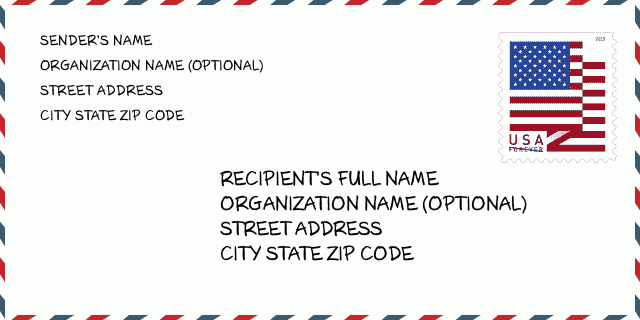
Address Example
AVON IN 46123-7980
UNITED STATES OF AMERICA
46123-7980 Envelope Example

-
This is an example of U.S envelope. Fill in the sender's information at the top left and the recipient information at the bottom right. The necessary information is sender/recipient's full name, street address, city, state and zip code. The recipient address information has been given for your reference. Generally, If you are not sure of the full 9-digit zip code, you can only fill in the 5-digit zip code to avoid loss of package.
46123-7980 Basic Meaning
-
What does each digit of ZIP Code 46123-7980 stands for? ZIP+4 Code consists of two parts, the first five digits can be located to the post office, and the last four digits can identify a geographic segment within the five-digit delivery area. The 6-7 digits designate sector or several blocks, and the 8-9 digits designate segment or one side of a street.
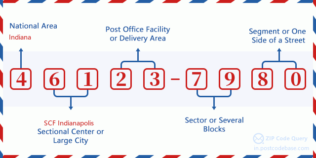

- ·Carrier Route ID?
A 4-digit code assigned to a mail delivery or collection route within a 5-digit ZIP Code. The first character of this identification is alphabetical, and the last three are numeric: Bnnn = PO box Hnnn = Highway contract Rnnn = Rural route Cnnn = City delivery Gnnn = General delivery: R039 (Rural route)
- ·ZIP Add-On Low Sector?
The ZIP Add-On Low Sector and the ZIP Add-On Low Segment together form the ZIP Add-On Low Number. The ZIP Add-On Low Number is the last four positions of a ZIP+4 code; the low-end ZIP add-on in a range of codes; the add-on of the first ZIP+4 code in a consecutive series of ZIP+4 codes assigned to the delivery address. For example, most delivery addresses are assigned a single ZIP+4 code. However, large companies may be given a range of ZIP+4 codes that can be used to route mail to specific departments. A range of ZIP+4 codes can also be assigned to a corresponding range of post office boxes, and each box is mapped, one-to-one, with a ZIP+4 code in the range. A single post office box can also be assigned a range of ZIP+4 codes.: 79
- ·ZIP Add-On Low Segment?
The ZIP Add-On Low Sector and the ZIP Add-On Low Segment together form the ZIP Add-On Low Number. The ZIP Add-On Low Number is the last four positions of a ZIP+4 code; the low-end ZIP add-on in a range of codes; the add-on of the first ZIP+4 code in a consecutive series of ZIP+4 codes assigned to the delivery address. For example, most delivery addresses are assigned a single ZIP+4 code. However, large companies may be given a range of ZIP+4 codes that can be used to route mail to specific departments. A range of ZIP+4 codes can also be assigned to a corresponding range of post office boxes, and each box is mapped, one-to-one, with a ZIP+4 code in the range. A single post office box can also be assigned a range of ZIP+4 codes.: 80
- ·ZIP Add-On High Sector?
The ZIP Add-On High Sector and the ZIP Add-On High Segment together form the ZIP Add-On High Number, which is the high-end ZIP add-on in a range of codes; the add-on of the last ZIP+4 code in a consecutive series of ZIP+4 codes assigned to the delivery address. Most delivery addresses are assigned a single ZIP+4 code; however, large companies may be given a range of ZIP+4 codes that can be used to route mail to specific departments. A range of ZIP+4 codes can also be assigned to a corresponding range of post office boxes, and each box is mapped, one-to-one, with a ZIP+4 code in the range. A single post office box can also be assigned a range of ZIP+4 codes. (See also ZIP Add-On Code.): 79
- ·ZIP Add-On High Segment?
The ZIP Add-On High Sector and the ZIP Add-On High Segment together form the ZIP Add-On High Number, which is the high-end ZIP add-on in a range of codes; the add-on of the last ZIP+4 code in a consecutive series of ZIP+4 codes assigned to the delivery address. Most delivery addresses are assigned a single ZIP+4 code; however, large companies may be given a range of ZIP+4 codes that can be used to route mail to specific departments. A range of ZIP+4 codes can also be assigned to a corresponding range of post office boxes, and each box is mapped, one-to-one, with a ZIP+4 code in the range. A single post office box can also be assigned a range of ZIP+4 codes. (See also ZIP Add-On Code.): 80
- ·ZIP Code Add On: 7980
- ·Range?
The range of +4 codes. Summing the +4 Code and the +4 Range will give you the high end of the range of +4 Codes that pertain to this ZIP Code.: 0
- ·Base Alternate Code?
Code that specifies whether a record is a base (preferred) or alternate record. Base records (represented as "B") can represent a range of addresses or an individual address, such as a firm record, while alternate records (represented as "A") are individual delivery points. Government deliveries will only be listed on alternate records with the appropriate government building indicator (federal, state, or city) set.: Base
- ·LACS Status Indicator?
The Locatable Address Conversion Service (LACS) indicator describes records that have been converted to the LACS system (a product/system that allows mailers to identify and convert a rural route address to a city-style address). Rural route and some city addresses are being modified to city-style addresses so that emergency services (i.e., ambulances, police, etc.) can find these addresses more efficiently.: Locatable Address Conversion Service
- ·Finance Number?
A code assigned to Postal Service facilities (primarily post offices) to collect cost and statistical data and compile revenue and expense data. The state number comprises the first two positions of the finance number.: 172090
- ·Congressional District Number?
A standard value identifying a geographic area within the United States served by a member of the US House of Representatives or Senate. If Army/Air Force (APO) or fleet post office (FPO), this column will be blank. If there is only one member of Congress within a state, the code will be "AL" (at large).: 04
- ·Preferred Last Line City State Key?
An index to the City State file that provides the preferred last-line name for this address range.: X1C654
Online Map

This is online map of the address 10900 E (East) US HIGHWAY 36 AVON. You may use button to move and zoom in / out. The map information is for reference only.
Address: 10900 (From 10900 To 10999) E (East) US HIGHWAY 36, AVON, IN 46123-7980, USA
Comment


Add new comment