Address: 9800 (From 9800 To 9899) W (West) 600 N (North), ARLINGTON, IN 46104-9404, USA
What's 46104-9404? 46104-9404 is a ZIP Code 5 Plus 4 number of 9800 (From 9800 To 9899) W (West) 600 N (North), ARLINGTON, IN, USA. Below is detail information.
46104-9404 Basic Information

-
ZIP Code 5 Plus 4:
46104-9404 -
ZIP Code 5:
46104 -
Plus 4?94044-digits that are used to identify a geographic segment within the 5-digit delivery area, such as a city block or a group of apartments or an individual high-volume receiver of mail, or any other unit that could use an extra identifier to aid in efficient mail sorting and delivery. This code is the low end of the range of +4 Codes that pertain to this ZIP Code. ZIP+4 Codes associated with nondelivery areas are composed of valid ZIP sector numbers and "ND" for the ZIP segment number, for example 12345-12ND. Non-deliverable areas are areas to which the USPS does not deliver mail, such as vacant lots and land that borders railroad tracks. Mailers should not match an address identified as a nondelivery area. If you absolutely must have numeric characters in the Plus4Code column, you may treat "ND" values as "00" (zero zero).:
-
Country:
U.S. - United States -
State:
IN - Indiana -
County:
CountyFIPS: 18139 - Rush County -
City:
ARLINGTON -
Street Predirectional:
W (West) -
Street?600The official name of a street as assigned by a local governing authority. The Street Name column contains only the street name and does not include directionals (EAST, WEST, etc.) or suffixes (ST, DR, BLVD, etc.). This element may also contain literals, such as PO BOX, GENERAL DELIVERY, USS, PSC, or UNIT. Numeric street names that have numeric components that are four characters (or less) in length at are justified such that the low-order digit of the number is positioned in the fourth position of the street name column. This shift is made so that the numeric street names appear in numeric sequence.:
-
Street Postdirectional?N (North)A geographic direction that precedes the street name. For Example: 472 MAIN ST N Street Pre-Direction Abbreviation = N Spaces = No pre-direction N = North NE = Northeast E = East SE = Southeast S = South SW = Southwest W = West NW = Northwest:
-
Record Type?S: StreetAn alphabetic value that identifies the type of data in the record. Record type codes include the following: G = General delivery H = Highrise F = Firm S = Street P = PO box R = Rural route/highway contract:
Address

- Address Primary Low Number?
A house, rural route, highway contract box, or post office box number; the numeric or alphanumeric component of an address preceding the street name; the low-end address in a range of addresses. Often referred to as house number.: 9800
- Address Primary High Number?
A house, rural route, contract box, or Post Office box number. The numeric or alphanumeric component of an address preceding the street name. The high-end address in a range of addresses. Often referred to as house number.: 9899
- Address Primary Odd / Even Code?
Code that identifies the side or sides of a street for which a given address range is applicable. For street, highrise, firm and multi-carrier records, B = Both sides of a street, E = Even side of a street (even-numbered addresses in the range); O = Odd side of a street (odd-numbered addresses in the range). For general delivery, post office box, and rural route/highway contract records, this code will always be "B" (both).: Both of Odd and Even
- Primary Range: 9800, 9801, 9802, 9803, 9804, 9805, 9806, 9807, 9808, 9809, 9810, 9811, 9812, 9813, 9814, 9815, 9816, 9817, 9818, 9819, 9820, 9821, 9822, 9823, 9824, 9825, 9826, 9827, 9828, 9829, 9830, 9831, 9832, 9833, 9834, 9835, 9836, 9837, 9838, 9839, 9840, 9841, 9842, 9843, 9844, 9845, 9846, 9847, 9848, 9849, 9850, 9851, 9852, 9853, 9854, 9855, 9856, 9857, 9858, 9859, 9860, 9861, 9862, 9863, 9864, 9865, 9866, 9867, 9868, 9869, 9870, 9871, 9872, 9873, 9874, 9875, 9876, 9877, 9878, 9879, 9880, 9881, 9882, 9883, 9884, 9885, 9886, 9887, 9888, 9889, 9890, 9891, 9892, 9893, 9894, 9895, 9896, 9897, 9898, 9899.
Please click the "More Address Examples" to view the whole list.
9800 W (West) 600 N (North), ARLINGTON, IN 46104-9404
9801 W (West) 600 N (North), ARLINGTON, IN 46104-9404
9802 W (West) 600 N (North), ARLINGTON, IN 46104-9404
9803 W (West) 600 N (North), ARLINGTON, IN 46104-9404
9804 W (West) 600 N (North), ARLINGTON, IN 46104-9404
9805 W (West) 600 N (North), ARLINGTON, IN 46104-9404
9806 W (West) 600 N (North), ARLINGTON, IN 46104-9404
9807 W (West) 600 N (North), ARLINGTON, IN 46104-9404
9808 W (West) 600 N (North), ARLINGTON, IN 46104-9404
9809 W (West) 600 N (North), ARLINGTON, IN 46104-9404
9810 W (West) 600 N (North), ARLINGTON, IN 46104-9404
9811 W (West) 600 N (North), ARLINGTON, IN 46104-9404
9812 W (West) 600 N (North), ARLINGTON, IN 46104-9404
9813 W (West) 600 N (North), ARLINGTON, IN 46104-9404
9814 W (West) 600 N (North), ARLINGTON, IN 46104-9404
9815 W (West) 600 N (North), ARLINGTON, IN 46104-9404
9816 W (West) 600 N (North), ARLINGTON, IN 46104-9404
9817 W (West) 600 N (North), ARLINGTON, IN 46104-9404
9818 W (West) 600 N (North), ARLINGTON, IN 46104-9404
9819 W (West) 600 N (North), ARLINGTON, IN 46104-9404
9820 W (West) 600 N (North), ARLINGTON, IN 46104-9404
9821 W (West) 600 N (North), ARLINGTON, IN 46104-9404
9822 W (West) 600 N (North), ARLINGTON, IN 46104-9404
9823 W (West) 600 N (North), ARLINGTON, IN 46104-9404
9824 W (West) 600 N (North), ARLINGTON, IN 46104-9404
9825 W (West) 600 N (North), ARLINGTON, IN 46104-9404
9826 W (West) 600 N (North), ARLINGTON, IN 46104-9404
9827 W (West) 600 N (North), ARLINGTON, IN 46104-9404
9828 W (West) 600 N (North), ARLINGTON, IN 46104-9404
9829 W (West) 600 N (North), ARLINGTON, IN 46104-9404
9830 W (West) 600 N (North), ARLINGTON, IN 46104-9404
9831 W (West) 600 N (North), ARLINGTON, IN 46104-9404
9832 W (West) 600 N (North), ARLINGTON, IN 46104-9404
9833 W (West) 600 N (North), ARLINGTON, IN 46104-9404
9834 W (West) 600 N (North), ARLINGTON, IN 46104-9404
9835 W (West) 600 N (North), ARLINGTON, IN 46104-9404
9836 W (West) 600 N (North), ARLINGTON, IN 46104-9404
9837 W (West) 600 N (North), ARLINGTON, IN 46104-9404
9838 W (West) 600 N (North), ARLINGTON, IN 46104-9404
9839 W (West) 600 N (North), ARLINGTON, IN 46104-9404
9840 W (West) 600 N (North), ARLINGTON, IN 46104-9404
9841 W (West) 600 N (North), ARLINGTON, IN 46104-9404
9842 W (West) 600 N (North), ARLINGTON, IN 46104-9404
9843 W (West) 600 N (North), ARLINGTON, IN 46104-9404
9844 W (West) 600 N (North), ARLINGTON, IN 46104-9404
9845 W (West) 600 N (North), ARLINGTON, IN 46104-9404
9846 W (West) 600 N (North), ARLINGTON, IN 46104-9404
9847 W (West) 600 N (North), ARLINGTON, IN 46104-9404
9848 W (West) 600 N (North), ARLINGTON, IN 46104-9404
9849 W (West) 600 N (North), ARLINGTON, IN 46104-9404
9850 W (West) 600 N (North), ARLINGTON, IN 46104-9404
9851 W (West) 600 N (North), ARLINGTON, IN 46104-9404
9852 W (West) 600 N (North), ARLINGTON, IN 46104-9404
9853 W (West) 600 N (North), ARLINGTON, IN 46104-9404
9854 W (West) 600 N (North), ARLINGTON, IN 46104-9404
9855 W (West) 600 N (North), ARLINGTON, IN 46104-9404
9856 W (West) 600 N (North), ARLINGTON, IN 46104-9404
9857 W (West) 600 N (North), ARLINGTON, IN 46104-9404
9858 W (West) 600 N (North), ARLINGTON, IN 46104-9404
9859 W (West) 600 N (North), ARLINGTON, IN 46104-9404
9860 W (West) 600 N (North), ARLINGTON, IN 46104-9404
9861 W (West) 600 N (North), ARLINGTON, IN 46104-9404
9862 W (West) 600 N (North), ARLINGTON, IN 46104-9404
9863 W (West) 600 N (North), ARLINGTON, IN 46104-9404
9864 W (West) 600 N (North), ARLINGTON, IN 46104-9404
9865 W (West) 600 N (North), ARLINGTON, IN 46104-9404
9866 W (West) 600 N (North), ARLINGTON, IN 46104-9404
9867 W (West) 600 N (North), ARLINGTON, IN 46104-9404
9868 W (West) 600 N (North), ARLINGTON, IN 46104-9404
9869 W (West) 600 N (North), ARLINGTON, IN 46104-9404
9870 W (West) 600 N (North), ARLINGTON, IN 46104-9404
9871 W (West) 600 N (North), ARLINGTON, IN 46104-9404
9872 W (West) 600 N (North), ARLINGTON, IN 46104-9404
9873 W (West) 600 N (North), ARLINGTON, IN 46104-9404
9874 W (West) 600 N (North), ARLINGTON, IN 46104-9404
9875 W (West) 600 N (North), ARLINGTON, IN 46104-9404
9876 W (West) 600 N (North), ARLINGTON, IN 46104-9404
9877 W (West) 600 N (North), ARLINGTON, IN 46104-9404
9878 W (West) 600 N (North), ARLINGTON, IN 46104-9404
9879 W (West) 600 N (North), ARLINGTON, IN 46104-9404
9880 W (West) 600 N (North), ARLINGTON, IN 46104-9404
9881 W (West) 600 N (North), ARLINGTON, IN 46104-9404
9882 W (West) 600 N (North), ARLINGTON, IN 46104-9404
9883 W (West) 600 N (North), ARLINGTON, IN 46104-9404
9884 W (West) 600 N (North), ARLINGTON, IN 46104-9404
9885 W (West) 600 N (North), ARLINGTON, IN 46104-9404
9886 W (West) 600 N (North), ARLINGTON, IN 46104-9404
9887 W (West) 600 N (North), ARLINGTON, IN 46104-9404
9888 W (West) 600 N (North), ARLINGTON, IN 46104-9404
9889 W (West) 600 N (North), ARLINGTON, IN 46104-9404
9890 W (West) 600 N (North), ARLINGTON, IN 46104-9404
9891 W (West) 600 N (North), ARLINGTON, IN 46104-9404
9892 W (West) 600 N (North), ARLINGTON, IN 46104-9404
9893 W (West) 600 N (North), ARLINGTON, IN 46104-9404
9894 W (West) 600 N (North), ARLINGTON, IN 46104-9404
9895 W (West) 600 N (North), ARLINGTON, IN 46104-9404
9896 W (West) 600 N (North), ARLINGTON, IN 46104-9404
9897 W (West) 600 N (North), ARLINGTON, IN 46104-9404
9898 W (West) 600 N (North), ARLINGTON, IN 46104-9404
9899 W (West) 600 N (North), ARLINGTON, IN 46104-9404
Address Example
ARLINGTON IN 46104-9404
UNITED STATES OF AMERICA
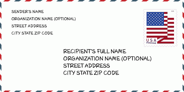
46104-9404 Envelope Example

-
This is an example of U.S envelope. Fill in the sender's information at the top left and the recipient information at the bottom right. The necessary information is sender/recipient's full name, street address, city, state and zip code. The recipient address information has been given for your reference. Generally, If you are not sure of the full 9-digit zip code, you can only fill in the 5-digit zip code to avoid loss of package.
46104-9404 Basic Meaning
-
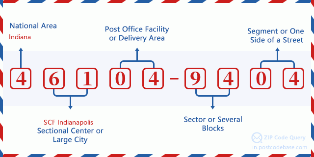
What does each digit of ZIP Code 46104-9404 stands for? ZIP+4 Code consists of two parts, the first five digits can be located to the post office, and the last four digits can identify a geographic segment within the five-digit delivery area. The 6-7 digits designate sector or several blocks, and the 8-9 digits designate segment or one side of a street.

- ·Carrier Route ID?
A 4-digit code assigned to a mail delivery or collection route within a 5-digit ZIP Code. The first character of this identification is alphabetical, and the last three are numeric: Bnnn = PO box Hnnn = Highway contract Rnnn = Rural route Cnnn = City delivery Gnnn = General delivery: R071 (Rural route)
- ·ZIP Add-On Low Sector?
The ZIP Add-On Low Sector and the ZIP Add-On Low Segment together form the ZIP Add-On Low Number. The ZIP Add-On Low Number is the last four positions of a ZIP+4 code; the low-end ZIP add-on in a range of codes; the add-on of the first ZIP+4 code in a consecutive series of ZIP+4 codes assigned to the delivery address. For example, most delivery addresses are assigned a single ZIP+4 code. However, large companies may be given a range of ZIP+4 codes that can be used to route mail to specific departments. A range of ZIP+4 codes can also be assigned to a corresponding range of post office boxes, and each box is mapped, one-to-one, with a ZIP+4 code in the range. A single post office box can also be assigned a range of ZIP+4 codes.: 94
- ·ZIP Add-On Low Segment?
The ZIP Add-On Low Sector and the ZIP Add-On Low Segment together form the ZIP Add-On Low Number. The ZIP Add-On Low Number is the last four positions of a ZIP+4 code; the low-end ZIP add-on in a range of codes; the add-on of the first ZIP+4 code in a consecutive series of ZIP+4 codes assigned to the delivery address. For example, most delivery addresses are assigned a single ZIP+4 code. However, large companies may be given a range of ZIP+4 codes that can be used to route mail to specific departments. A range of ZIP+4 codes can also be assigned to a corresponding range of post office boxes, and each box is mapped, one-to-one, with a ZIP+4 code in the range. A single post office box can also be assigned a range of ZIP+4 codes.: 04
- ·ZIP Add-On High Sector?
The ZIP Add-On High Sector and the ZIP Add-On High Segment together form the ZIP Add-On High Number, which is the high-end ZIP add-on in a range of codes; the add-on of the last ZIP+4 code in a consecutive series of ZIP+4 codes assigned to the delivery address. Most delivery addresses are assigned a single ZIP+4 code; however, large companies may be given a range of ZIP+4 codes that can be used to route mail to specific departments. A range of ZIP+4 codes can also be assigned to a corresponding range of post office boxes, and each box is mapped, one-to-one, with a ZIP+4 code in the range. A single post office box can also be assigned a range of ZIP+4 codes. (See also ZIP Add-On Code.): 94
- ·ZIP Add-On High Segment?
The ZIP Add-On High Sector and the ZIP Add-On High Segment together form the ZIP Add-On High Number, which is the high-end ZIP add-on in a range of codes; the add-on of the last ZIP+4 code in a consecutive series of ZIP+4 codes assigned to the delivery address. Most delivery addresses are assigned a single ZIP+4 code; however, large companies may be given a range of ZIP+4 codes that can be used to route mail to specific departments. A range of ZIP+4 codes can also be assigned to a corresponding range of post office boxes, and each box is mapped, one-to-one, with a ZIP+4 code in the range. A single post office box can also be assigned a range of ZIP+4 codes. (See also ZIP Add-On Code.): 04
- ·ZIP Code Add On: 9404
- ·Range?
The range of +4 codes. Summing the +4 Code and the +4 Range will give you the high end of the range of +4 Codes that pertain to this ZIP Code.: 0
- ·Base Alternate Code?
Code that specifies whether a record is a base (preferred) or alternate record. Base records (represented as "B") can represent a range of addresses or an individual address, such as a firm record, while alternate records (represented as "A") are individual delivery points. Government deliveries will only be listed on alternate records with the appropriate government building indicator (federal, state, or city) set.: Base
- ·Finance Number?
A code assigned to Postal Service facilities (primarily post offices) to collect cost and statistical data and compile revenue and expense data. The state number comprises the first two positions of the finance number.: 170275
- ·Congressional District Number?
A standard value identifying a geographic area within the United States served by a member of the US House of Representatives or Senate. If Army/Air Force (APO) or fleet post office (FPO), this column will be blank. If there is only one member of Congress within a state, the code will be "AL" (at large).: 06
- ·Preferred Last Line City State Key?
An index to the City State file that provides the preferred last-line name for this address range.: X11474
Online Map

This is online map of the address 9800 W (West) 600 ARLINGTON. You may use button to move and zoom in / out. The map information is for reference only.
Address: 9800 (From 9800 To 9899) W (West) 600 N (North), ARLINGTON, IN 46104-9404, USA
Comment


Add new comment