Адрес: 6400 (From 6400 To 6499) W (West) US HIGHWAY 20, ANGOLA, IN 46703-8638, USA
Что такое 46703-8638? 46703-8638 является почтовым индексом 6400 (From 6400 To 6499) W (West) US HIGHWAY 20, ANGOLA, IN, USA 5 плюс 4. Ниже приведена подробная информация.
46703-8638 Основная информация

-
Индекс 5 Plus 4:
46703-8638 -
Индекс 5:
46703 -
Plus 4?86384-digits that are used to identify a geographic segment within the 5-digit delivery area, such as a city block or a group of apartments or an individual high-volume receiver of mail, or any other unit that could use an extra identifier to aid in efficient mail sorting and delivery. This code is the low end of the range of +4 Codes that pertain to this ZIP Code. ZIP+4 Codes associated with nondelivery areas are composed of valid ZIP sector numbers and "ND" for the ZIP segment number, for example 12345-12ND. Non-deliverable areas are areas to which the USPS does not deliver mail, such as vacant lots and land that borders railroad tracks. Mailers should not match an address identified as a nondelivery area. If you absolutely must have numeric characters in the Plus4Code column, you may treat "ND" values as "00" (zero zero).:
-
Страна:
U.S. - Соединенные Штаты -
Область :
IN - Индиана -
Округ:
CountyFIPS: 18151 - Steuben County -
Город:
ANGOLA -
Переднее направление улицы :
W (West) -
Улица?US HIGHWAY 20The official name of a street as assigned by a local governing authority. The Street Name column contains only the street name and does not include directionals (EAST, WEST, etc.) or suffixes (ST, DR, BLVD, etc.). This element may also contain literals, such as PO BOX, GENERAL DELIVERY, USS, PSC, or UNIT. Numeric street names that have numeric components that are four characters (or less) in length at are justified such that the low-order digit of the number is positioned in the fourth position of the street name column. This shift is made so that the numeric street names appear in numeric sequence.:
-
Тип записи?S: УлицаAn alphabetic value that identifies the type of data in the record. Record type codes include the following: G = General delivery H = Highrise F = Firm S = Street P = PO box R = Rural route/highway contract:
Адрес

- Малое число главного адреса ?
A house, rural route, highway contract box, or post office box number; the numeric or alphanumeric component of an address preceding the street name; the low-end address in a range of addresses. Often referred to as house number.: 6400
- Большое число главного адреса ?
A house, rural route, contract box, or Post Office box number. The numeric or alphanumeric component of an address preceding the street name. The high-end address in a range of addresses. Often referred to as house number.: 6499
- Нечетный / четный код главного адреса ?
Code that identifies the side or sides of a street for which a given address range is applicable. For street, highrise, firm and multi-carrier records, B = Both sides of a street, E = Even side of a street (even-numbered addresses in the range); O = Odd side of a street (odd-numbered addresses in the range). For general delivery, post office box, and rural route/highway contract records, this code will always be "B" (both).: Both of Odd and Even
- Первичный Диапазон: 6400, 6401, 6402, 6403, 6404, 6405, 6406, 6407, 6408, 6409, 6410, 6411, 6412, 6413, 6414, 6415, 6416, 6417, 6418, 6419, 6420, 6421, 6422, 6423, 6424, 6425, 6426, 6427, 6428, 6429, 6430, 6431, 6432, 6433, 6434, 6435, 6436, 6437, 6438, 6439, 6440, 6441, 6442, 6443, 6444, 6445, 6446, 6447, 6448, 6449, 6450, 6451, 6452, 6453, 6454, 6455, 6456, 6457, 6458, 6459, 6460, 6461, 6462, 6463, 6464, 6465, 6466, 6467, 6468, 6469, 6470, 6471, 6472, 6473, 6474, 6475, 6476, 6477, 6478, 6479, 6480, 6481, 6482, 6483, 6484, 6485, 6486, 6487, 6488, 6489, 6490, 6491, 6492, 6493, 6494, 6495, 6496, 6497, 6498, 6499.
Нажмите "Больше примеров адресов", чтобы просмотреть весь список.
6400 W (West) US HIGHWAY 20, ANGOLA, IN 46703-8638
6401 W (West) US HIGHWAY 20, ANGOLA, IN 46703-8638
6402 W (West) US HIGHWAY 20, ANGOLA, IN 46703-8638
6403 W (West) US HIGHWAY 20, ANGOLA, IN 46703-8638
6404 W (West) US HIGHWAY 20, ANGOLA, IN 46703-8638
6405 W (West) US HIGHWAY 20, ANGOLA, IN 46703-8638
6406 W (West) US HIGHWAY 20, ANGOLA, IN 46703-8638
6407 W (West) US HIGHWAY 20, ANGOLA, IN 46703-8638
6408 W (West) US HIGHWAY 20, ANGOLA, IN 46703-8638
6409 W (West) US HIGHWAY 20, ANGOLA, IN 46703-8638
6410 W (West) US HIGHWAY 20, ANGOLA, IN 46703-8638
6411 W (West) US HIGHWAY 20, ANGOLA, IN 46703-8638
6412 W (West) US HIGHWAY 20, ANGOLA, IN 46703-8638
6413 W (West) US HIGHWAY 20, ANGOLA, IN 46703-8638
6414 W (West) US HIGHWAY 20, ANGOLA, IN 46703-8638
6415 W (West) US HIGHWAY 20, ANGOLA, IN 46703-8638
6416 W (West) US HIGHWAY 20, ANGOLA, IN 46703-8638
6417 W (West) US HIGHWAY 20, ANGOLA, IN 46703-8638
6418 W (West) US HIGHWAY 20, ANGOLA, IN 46703-8638
6419 W (West) US HIGHWAY 20, ANGOLA, IN 46703-8638
6420 W (West) US HIGHWAY 20, ANGOLA, IN 46703-8638
6421 W (West) US HIGHWAY 20, ANGOLA, IN 46703-8638
6422 W (West) US HIGHWAY 20, ANGOLA, IN 46703-8638
6423 W (West) US HIGHWAY 20, ANGOLA, IN 46703-8638
6424 W (West) US HIGHWAY 20, ANGOLA, IN 46703-8638
6425 W (West) US HIGHWAY 20, ANGOLA, IN 46703-8638
6426 W (West) US HIGHWAY 20, ANGOLA, IN 46703-8638
6427 W (West) US HIGHWAY 20, ANGOLA, IN 46703-8638
6428 W (West) US HIGHWAY 20, ANGOLA, IN 46703-8638
6429 W (West) US HIGHWAY 20, ANGOLA, IN 46703-8638
6430 W (West) US HIGHWAY 20, ANGOLA, IN 46703-8638
6431 W (West) US HIGHWAY 20, ANGOLA, IN 46703-8638
6432 W (West) US HIGHWAY 20, ANGOLA, IN 46703-8638
6433 W (West) US HIGHWAY 20, ANGOLA, IN 46703-8638
6434 W (West) US HIGHWAY 20, ANGOLA, IN 46703-8638
6435 W (West) US HIGHWAY 20, ANGOLA, IN 46703-8638
6436 W (West) US HIGHWAY 20, ANGOLA, IN 46703-8638
6437 W (West) US HIGHWAY 20, ANGOLA, IN 46703-8638
6438 W (West) US HIGHWAY 20, ANGOLA, IN 46703-8638
6439 W (West) US HIGHWAY 20, ANGOLA, IN 46703-8638
6440 W (West) US HIGHWAY 20, ANGOLA, IN 46703-8638
6441 W (West) US HIGHWAY 20, ANGOLA, IN 46703-8638
6442 W (West) US HIGHWAY 20, ANGOLA, IN 46703-8638
6443 W (West) US HIGHWAY 20, ANGOLA, IN 46703-8638
6444 W (West) US HIGHWAY 20, ANGOLA, IN 46703-8638
6445 W (West) US HIGHWAY 20, ANGOLA, IN 46703-8638
6446 W (West) US HIGHWAY 20, ANGOLA, IN 46703-8638
6447 W (West) US HIGHWAY 20, ANGOLA, IN 46703-8638
6448 W (West) US HIGHWAY 20, ANGOLA, IN 46703-8638
6449 W (West) US HIGHWAY 20, ANGOLA, IN 46703-8638
6450 W (West) US HIGHWAY 20, ANGOLA, IN 46703-8638
6451 W (West) US HIGHWAY 20, ANGOLA, IN 46703-8638
6452 W (West) US HIGHWAY 20, ANGOLA, IN 46703-8638
6453 W (West) US HIGHWAY 20, ANGOLA, IN 46703-8638
6454 W (West) US HIGHWAY 20, ANGOLA, IN 46703-8638
6455 W (West) US HIGHWAY 20, ANGOLA, IN 46703-8638
6456 W (West) US HIGHWAY 20, ANGOLA, IN 46703-8638
6457 W (West) US HIGHWAY 20, ANGOLA, IN 46703-8638
6458 W (West) US HIGHWAY 20, ANGOLA, IN 46703-8638
6459 W (West) US HIGHWAY 20, ANGOLA, IN 46703-8638
6460 W (West) US HIGHWAY 20, ANGOLA, IN 46703-8638
6461 W (West) US HIGHWAY 20, ANGOLA, IN 46703-8638
6462 W (West) US HIGHWAY 20, ANGOLA, IN 46703-8638
6463 W (West) US HIGHWAY 20, ANGOLA, IN 46703-8638
6464 W (West) US HIGHWAY 20, ANGOLA, IN 46703-8638
6465 W (West) US HIGHWAY 20, ANGOLA, IN 46703-8638
6466 W (West) US HIGHWAY 20, ANGOLA, IN 46703-8638
6467 W (West) US HIGHWAY 20, ANGOLA, IN 46703-8638
6468 W (West) US HIGHWAY 20, ANGOLA, IN 46703-8638
6469 W (West) US HIGHWAY 20, ANGOLA, IN 46703-8638
6470 W (West) US HIGHWAY 20, ANGOLA, IN 46703-8638
6471 W (West) US HIGHWAY 20, ANGOLA, IN 46703-8638
6472 W (West) US HIGHWAY 20, ANGOLA, IN 46703-8638
6473 W (West) US HIGHWAY 20, ANGOLA, IN 46703-8638
6474 W (West) US HIGHWAY 20, ANGOLA, IN 46703-8638
6475 W (West) US HIGHWAY 20, ANGOLA, IN 46703-8638
6476 W (West) US HIGHWAY 20, ANGOLA, IN 46703-8638
6477 W (West) US HIGHWAY 20, ANGOLA, IN 46703-8638
6478 W (West) US HIGHWAY 20, ANGOLA, IN 46703-8638
6479 W (West) US HIGHWAY 20, ANGOLA, IN 46703-8638
6480 W (West) US HIGHWAY 20, ANGOLA, IN 46703-8638
6481 W (West) US HIGHWAY 20, ANGOLA, IN 46703-8638
6482 W (West) US HIGHWAY 20, ANGOLA, IN 46703-8638
6483 W (West) US HIGHWAY 20, ANGOLA, IN 46703-8638
6484 W (West) US HIGHWAY 20, ANGOLA, IN 46703-8638
6485 W (West) US HIGHWAY 20, ANGOLA, IN 46703-8638
6486 W (West) US HIGHWAY 20, ANGOLA, IN 46703-8638
6487 W (West) US HIGHWAY 20, ANGOLA, IN 46703-8638
6488 W (West) US HIGHWAY 20, ANGOLA, IN 46703-8638
6489 W (West) US HIGHWAY 20, ANGOLA, IN 46703-8638
6490 W (West) US HIGHWAY 20, ANGOLA, IN 46703-8638
6491 W (West) US HIGHWAY 20, ANGOLA, IN 46703-8638
6492 W (West) US HIGHWAY 20, ANGOLA, IN 46703-8638
6493 W (West) US HIGHWAY 20, ANGOLA, IN 46703-8638
6494 W (West) US HIGHWAY 20, ANGOLA, IN 46703-8638
6495 W (West) US HIGHWAY 20, ANGOLA, IN 46703-8638
6496 W (West) US HIGHWAY 20, ANGOLA, IN 46703-8638
6497 W (West) US HIGHWAY 20, ANGOLA, IN 46703-8638
6498 W (West) US HIGHWAY 20, ANGOLA, IN 46703-8638
6499 W (West) US HIGHWAY 20, ANGOLA, IN 46703-8638
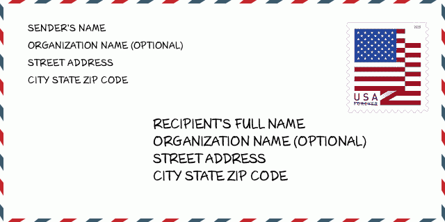
Адрес Пример
ANGOLA IN 46703-8638
UNITED STATES OF AMERICA
46703-8638 Пример конверта

-
Это пример конверта США. Введите информацию об отправителе в верхнем левом углу и информацию о получателе в правом нижнем углу. Необходимая информация - полное имя отправителя / получателя, почтовый адрес, город, штат и почтовый индекс. Информация об адресе получателя предоставлена для справки. Как правило, если вы не уверены в полном 9-значном почтовом индексе, вы можете ввести только 5-значный почтовый индекс, чтобы избежать потери посылки.
46703-8638 Основное значение
-
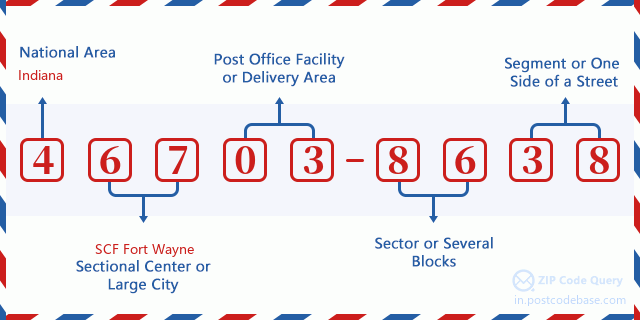
Что означает каждая цифра почтового индекса 46703-8638? Индекс ZIP + 4 состоит из двух частей, первые пять цифр могут быть указаны для почтового отделения, а последние четыре цифры могут идентифицировать географический сегмент в пределах пятизначной зоны доставки. Цифры 6-7 обозначают сектор или несколько кварталов, а цифры 8-9 обозначают сегмент или одну сторону улицы.

- ·Путь перевозки ID?
A 4-digit code assigned to a mail delivery or collection route within a 5-digit ZIP Code. The first character of this identification is alphabetical, and the last three are numeric: Bnnn = PO box Hnnn = Highway contract Rnnn = Rural route Cnnn = City delivery Gnnn = General delivery: R007 (Сельский маршрут )
- ·ZIP Add-On низкая часть ?
The ZIP Add-On Low Sector and the ZIP Add-On Low Segment together form the ZIP Add-On Low Number. The ZIP Add-On Low Number is the last four positions of a ZIP+4 code; the low-end ZIP add-on in a range of codes; the add-on of the first ZIP+4 code in a consecutive series of ZIP+4 codes assigned to the delivery address. For example, most delivery addresses are assigned a single ZIP+4 code. However, large companies may be given a range of ZIP+4 codes that can be used to route mail to specific departments. A range of ZIP+4 codes can also be assigned to a corresponding range of post office boxes, and each box is mapped, one-to-one, with a ZIP+4 code in the range. A single post office box can also be assigned a range of ZIP+4 codes.: 86
- ·ZIP Add-On низский сегмент ?
The ZIP Add-On Low Sector and the ZIP Add-On Low Segment together form the ZIP Add-On Low Number. The ZIP Add-On Low Number is the last four positions of a ZIP+4 code; the low-end ZIP add-on in a range of codes; the add-on of the first ZIP+4 code in a consecutive series of ZIP+4 codes assigned to the delivery address. For example, most delivery addresses are assigned a single ZIP+4 code. However, large companies may be given a range of ZIP+4 codes that can be used to route mail to specific departments. A range of ZIP+4 codes can also be assigned to a corresponding range of post office boxes, and each box is mapped, one-to-one, with a ZIP+4 code in the range. A single post office box can also be assigned a range of ZIP+4 codes.: 38
- ·ZIP Add-On высокая часть ?
The ZIP Add-On High Sector and the ZIP Add-On High Segment together form the ZIP Add-On High Number, which is the high-end ZIP add-on in a range of codes; the add-on of the last ZIP+4 code in a consecutive series of ZIP+4 codes assigned to the delivery address. Most delivery addresses are assigned a single ZIP+4 code; however, large companies may be given a range of ZIP+4 codes that can be used to route mail to specific departments. A range of ZIP+4 codes can also be assigned to a corresponding range of post office boxes, and each box is mapped, one-to-one, with a ZIP+4 code in the range. A single post office box can also be assigned a range of ZIP+4 codes. (See also ZIP Add-On Code.): 86
- ·ZIP Add-On высокий сегмент ?
The ZIP Add-On High Sector and the ZIP Add-On High Segment together form the ZIP Add-On High Number, which is the high-end ZIP add-on in a range of codes; the add-on of the last ZIP+4 code in a consecutive series of ZIP+4 codes assigned to the delivery address. Most delivery addresses are assigned a single ZIP+4 code; however, large companies may be given a range of ZIP+4 codes that can be used to route mail to specific departments. A range of ZIP+4 codes can also be assigned to a corresponding range of post office boxes, and each box is mapped, one-to-one, with a ZIP+4 code in the range. A single post office box can also be assigned a range of ZIP+4 codes. (See also ZIP Add-On Code.): 38
- ·Почтовый Индекс Добавить на : 8638
- ·Диапазон?
The range of +4 codes. Summing the +4 Code and the +4 Range will give you the high end of the range of +4 Codes that pertain to this ZIP Code.: 0
- ·Основной код для замены ?
Code that specifies whether a record is a base (preferred) or alternate record. Base records (represented as "B") can represent a range of addresses or an individual address, such as a firm record, while alternate records (represented as "A") are individual delivery points. Government deliveries will only be listed on alternate records with the appropriate government building indicator (federal, state, or city) set.: Основа
- ·Финансовое число ?
A code assigned to Postal Service facilities (primarily post offices) to collect cost and statistical data and compile revenue and expense data. The state number comprises the first two positions of the finance number.: 170220
- ·Парламентский номер зоны ?
A standard value identifying a geographic area within the United States served by a member of the US House of Representatives or Senate. If Army/Air Force (APO) or fleet post office (FPO), this column will be blank. If there is only one member of Congress within a state, the code will be "AL" (at large).: 03
- ·Код области города последней линии ?
An index to the City State file that provides the preferred last-line name for this address range.: X11459
Карта интернета

Это адрес 6400 W (West) US HIGHWAY 20 ANGOLA согласованная онлайновая электронная карта. Вы можете кнопкой в карте передвигать, пантографировать. Информация этой карты только для справки.
Адрес: 6400 (From 6400 To 6499) W (West) US HIGHWAY 20, ANGOLA, IN 46703-8638, USA
Комментарий


Добавить комментарий