Indirizzo: 1800 (From 1800 To 1898) EARHART ST, INDIANAPOLIS, IN 46203-22ND, USA
Che cos'è 46203-22ND? 46203-22ND è un codice di 5 Plus 4 numero di avviamento postale del 1800 (From 1800 To 1898) EARHART ST, INDIANAPOLIS, IN, USA. Di seguito è riportato informazioni dettagliate.
46203-22ND Informazioni di base

Via Predirezionale?
A geographic direction that precedes the street name.
| Strada?
The official name of a street as assigned by a local governing authority. The Street Name column contains only the street name and does not include directionals (EAST, WEST, etc.) or suffixes (ST, DR, BLVD, etc.). This element may also contain literals, such as PO BOX, GENERAL DELIVERY, USS, PSC, or UNIT. Numeric street names that have numeric components that are four characters (or less) in length at are justified such that the low-order digit of the number is positioned in the fourth position of the street name column. This shift is made so that the numeric street names appear in numeric sequence.
| Via Suffisso?
The street suffix:
For Example:
ST = Street
RD = Road
DR = Drive
LN = Lane
| Città | Tipo di Record?
An alphabetic value that identifies the type of data in the record. Record type codes include the following:
G = General delivery
H = Highrise
F = Firm
S = Street
P = PO box
R = Rural route/highway contract
| Stato |
|---|---|---|---|---|---|
| EARHART | ST | INDIANAPOLIS | S | valido | |
| S (South) | EWING | ST | INDIANAPOLIS | S | valido |
| S (South) | KEALING | AVE | INDIANAPOLIS | S | valido |
| ORANGE | ST | INDIANAPOLIS | S | valido | |
| PROSPECT | ST | INDIANAPOLIS | S | valido | |
| S (South) | SHERMAN | DR | INDIANAPOLIS | S | valido |
| TERRACE | AVE | INDIANAPOLIS | S | valido |
Indirizzo

46203-22ND corrisponde ai seguenti indirizzi.
| Elenco indirizzi | Stato |
|---|---|
| 1101 (From 1101 To 1199) EARHART ST, INDIANAPOLIS, IN 46203-22ND, USA | valido |
| 1300 (From 1300 To 1398) EARHART ST, INDIANAPOLIS, IN 46203-22ND, USA | valido |
| 1401 (From 1401 To 1499) EARHART ST, INDIANAPOLIS, IN 46203-22ND, USA | valido |
| 1501 (From 1501 To 1599) EARHART ST, INDIANAPOLIS, IN 46203-22ND, USA | valido |
| 1601 (From 1601 To 1699) EARHART ST, INDIANAPOLIS, IN 46203-22ND, USA | valido |
| 1701 (From 1701 To 1799) EARHART ST, INDIANAPOLIS, IN 46203-22ND, USA | valido |
| 1801 (From 1801 To 1899) EARHART ST, INDIANAPOLIS, IN 46203-22ND, USA | valido |
| 1300 (From 1300 To 1398) S (South) EWING ST, INDIANAPOLIS, IN 46203-22ND, USA | valido |
| 1301 (From 1301 To 1399) S (South) KEALING AVE, INDIANAPOLIS, IN 46203-22ND, USA | valido |
| 3600 (From 3600 To 3698) ORANGE ST, INDIANAPOLIS, IN 46203-22ND, USA | valido |
| 3601 (From 3601 To 3699) ORANGE ST, INDIANAPOLIS, IN 46203-22ND, USA | valido |
| 3700 (From 3700 To 3798) ORANGE ST, INDIANAPOLIS, IN 46203-22ND, USA | valido |
| 3100 (From 3100 To 3198) PROSPECT ST, INDIANAPOLIS, IN 46203-22ND, USA | valido |
| 3101 (From 3101 To 3199) PROSPECT ST, INDIANAPOLIS, IN 46203-22ND, USA | valido |
| 3200 (From 3200 To 3298) PROSPECT ST, INDIANAPOLIS, IN 46203-22ND, USA | valido |
| 3201 (From 3201 To 3299) PROSPECT ST, INDIANAPOLIS, IN 46203-22ND, USA | valido |
| 1400 (From 1400 To 1498) S (South) SHERMAN DR, INDIANAPOLIS, IN 46203-22ND, USA | valido |
| 3400 (From 3400 To 3498) TERRACE AVE, INDIANAPOLIS, IN 46203-22ND, USA | valido |
| 3501 (From 3501 To 3599) TERRACE AVE, INDIANAPOLIS, IN 46203-22ND, USA | valido |
| 3701 (From 3701 To 3799) TERRACE AVE, INDIANAPOLIS, IN 46203-22ND, USA | valido |
| 1201 (From 1201 To 1299) EARHART ST, INDIANAPOLIS, IN 46203-22ND, USA | valido |
| 1301 (From 1301 To 1399) EARHART ST, INDIANAPOLIS, IN 46203-22ND, USA | valido |
| 1500 (From 1500 To 1598) EARHART ST, INDIANAPOLIS, IN 46203-22ND, USA | valido |
| 1600 (From 1600 To 1698) EARHART ST, INDIANAPOLIS, IN 46203-22ND, USA | valido |
| 1700 (From 1700 To 1798) EARHART ST, INDIANAPOLIS, IN 46203-22ND, USA | valido |
| 1800 (From 1800 To 1898) EARHART ST, INDIANAPOLIS, IN 46203-22ND, USA | valido |
Fare clic sul "Altri esempi di indirizzi" per visualizzare l'intero elenco.
Indirizzo Esempio
INDIANAPOLIS IN 46203-22ND
UNITED STATES OF AMERICA
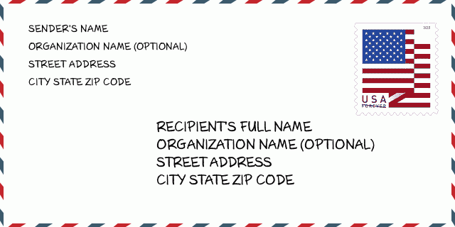
46203-22ND Esempio di busta

-
Questo è un esempio di busta statunitense. Inserisci le informazioni del mittente in alto a sinistra e le informazioni del destinatario in basso a destra. Le informazioni necessarie sono il nome completo del mittente/destinatario, l'indirizzo, la città, lo stato e il codice postale. Le informazioni sull'indirizzo del destinatario sono state fornite come riferimento. In generale, se non sei sicuro del codice postale completo di 9 cifre, puoi inserire solo il codice postale di 5 cifre per evitare la perdita del pacco.
46203-22ND Significato di base
-
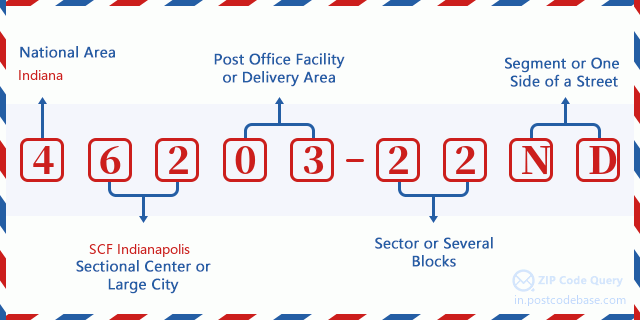
Cosa significa ogni cifra del CAP 46203-22ND? Il CAP+4 è composto da due parti, le prime cinque cifre possono essere localizzate all'ufficio postale e le ultime quattro cifre possono identificare un segmento geografico all'interno dell'area di consegna a cinque cifre. Le 6-7 cifre indicano un settore o più blocchi e le 8-9 cifre indicano un segmento o un lato di una strada.

Online Mappa

Questa è la online mappa dell'indirizzo 1800 EARHART ST, INDIANAPOLIS. Possibile usare bottone a muovere e sfrecciare in/fuori. Le informazioni di mappa è solo per riferimento.
Indirizzo: 1800 (From 1800 To 1898) EARHART ST, INDIANAPOLIS, IN 46203-22ND, USA
Commento


Aggiungi un commento