Cím: 401 (From 401 To 499) LOCUST ST, ANDERSON, IN 46016-10ND, USA
Mi az 46016-10ND? 46016-10ND az 401 (From 401 To 499) LOCUST ST, ANDERSON, IN, USA 5 jegyü irányitószám plusz 4 számjegy.Alábbiakban részletes információért.
46016-10ND Alapinformációk

Utca Predirectional?
A geographic direction that precedes the street name.
| Utca?
The official name of a street as assigned by a local governing authority. The Street Name column contains only the street name and does not include directionals (EAST, WEST, etc.) or suffixes (ST, DR, BLVD, etc.). This element may also contain literals, such as PO BOX, GENERAL DELIVERY, USS, PSC, or UNIT. Numeric street names that have numeric components that are four characters (or less) in length at are justified such that the low-order digit of the number is positioned in the fourth position of the street name column. This shift is made so that the numeric street names appear in numeric sequence.
| Utca Utótag?
The street suffix:
For Example:
ST = Street
RD = Road
DR = Drive
LN = Lane
| Város | Rekord Típus?
An alphabetic value that identifies the type of data in the record. Record type codes include the following:
G = General delivery
H = Highrise
F = Firm
S = Street
P = PO box
R = Rural route/highway contract
| Állapot |
|---|---|---|---|---|---|
| JOHN | ST | ANDERSON | S | érvényes | |
| LOCUST | ST | ANDERSON | S | érvényes | |
| HENRY | ST | ANDERSON | S | érvényes |
Cím

Az 46016-10ND a következő címeknek felel meg.
| Címlista | Állapot |
|---|---|
| 400 (From 400 To 498) JOHN ST, ANDERSON, IN 46016-10ND, USA | érvényes |
| 600 (From 600 To 698) JOHN ST, ANDERSON, IN 46016-10ND, USA | érvényes |
| 500 (From 500 To 598) LOCUST ST, ANDERSON, IN 46016-10ND, USA | érvényes |
| 500 (From 500 To 598) HENRY ST, ANDERSON, IN 46016-10ND, USA | érvényes |
| 401 (From 401 To 499) JOHN ST, ANDERSON, IN 46016-10ND, USA | érvényes |
| 401 (From 401 To 499) LOCUST ST, ANDERSON, IN 46016-10ND, USA | érvényes |
A teljes lista megtekintéséhez kattintson a "További címpéldák"-re.
Cím Példa
ANDERSON IN 46016-10ND
UNITED STATES OF AMERICA
46016-10ND Boríték Példa

-
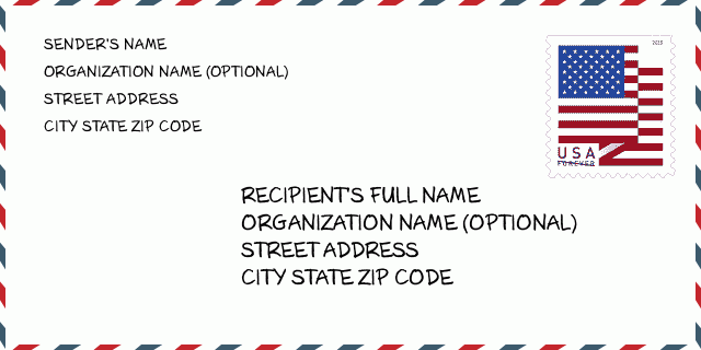
Ez egy példa az amerikai borítékra. Töltse ki a feladó adatait a bal felső sarokban, a címzett adatait pedig a jobb alsó sarokban. A szükséges információ a feladó/címzett teljes neve, utcája, városa, állam és irányítószám. A címzett információit megadtuk hivatkozásul. Általában, ha nem biztos a teljes 9 jegyű irányítószámban, akkor csak az 5 jegyű irányítószámot töltse ki a csomag elvesztésének elkerülése érdekében.
46016-10ND Alapvető jelentés
-
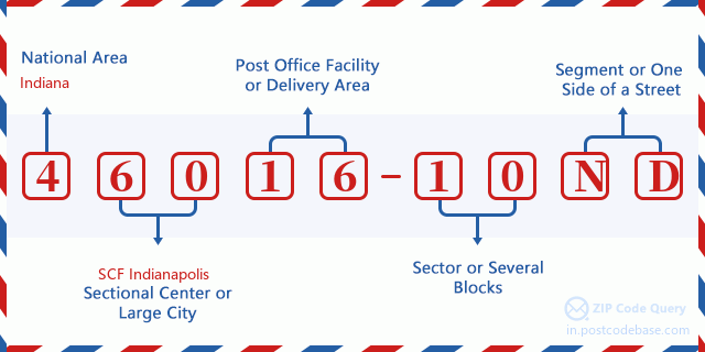
Mit jelent az 46016-10ND irányítószám minden számjegye? Az irányítószám két részből áll, az első öt számjegy a postahivatalig, az utolsó négy számjegy pedig egy földrajzi szegmenst azonosíthat az ötjegyű kézbesítési területen belül. A 6-7 számjegy egy szektort vagy több blokkot, a 8-9 számjegy pedig egy utcaszakaszt vagy egy oldalt jelöl.

Online Térkép

Ez az online térkép cim 401 LOCUST ST, ANDERSON. Lehet használni a Zoom in / out-ot. A térkép információk csak tájékoztató jellegü. A térkép információk csak tájékoztató jellegü.
Cím: 401 (From 401 To 499) LOCUST ST, ANDERSON, IN 46016-10ND, USA
Hozzászólás


Új hozzászólás