Adresse: 4600 (From 4600 To 4699) N (North) COUNTY ROAD 1100 E (East), FOREST, IN 46039-9501, USA
Was ist 46039-9501? 46039-9501 ist ein PLZ-Code 5 Plus 4 Zahl von 4600 (From 4600 To 4699) N (North) COUNTY ROAD 1100 E (East), FOREST, IN, USA. Nachfolgend finden Sie Detailinformationen.
46039-9501 Grundinformation

-
Postleitzahl 5 Plus 4:
46039-9501 -
Postleitzahl 5:
46039 -
Plus 4?95014-digits that are used to identify a geographic segment within the 5-digit delivery area, such as a city block or a group of apartments or an individual high-volume receiver of mail, or any other unit that could use an extra identifier to aid in efficient mail sorting and delivery. This code is the low end of the range of +4 Codes that pertain to this ZIP Code. ZIP+4 Codes associated with nondelivery areas are composed of valid ZIP sector numbers and "ND" for the ZIP segment number, for example 12345-12ND. Non-deliverable areas are areas to which the USPS does not deliver mail, such as vacant lots and land that borders railroad tracks. Mailers should not match an address identified as a nondelivery area. If you absolutely must have numeric characters in the Plus4Code column, you may treat "ND" values as "00" (zero zero).:
-
Land:
U.S. - Vereinigte Staaten -
Bundesland:
IN - Indiana -
Grafschaft:
CountyFIPS: 18023 - Clinton County -
Stadt:
FOREST -
Frontrichtung der Straße :
N (North) -
Straße?COUNTY ROAD 1100The official name of a street as assigned by a local governing authority. The Street Name column contains only the street name and does not include directionals (EAST, WEST, etc.) or suffixes (ST, DR, BLVD, etc.). This element may also contain literals, such as PO BOX, GENERAL DELIVERY, USS, PSC, or UNIT. Numeric street names that have numeric components that are four characters (or less) in length at are justified such that the low-order digit of the number is positioned in the fourth position of the street name column. This shift is made so that the numeric street names appear in numeric sequence.:
-
Hinterrichtung der Straße?E (East)A geographic direction that precedes the street name. For Example: 472 MAIN ST N Street Pre-Direction Abbreviation = N Spaces = No pre-direction N = North NE = Northeast E = East SE = Southeast S = South SW = Southwest W = West NW = Northwest:
-
Rekordtyp?S: StraßeAn alphabetic value that identifies the type of data in the record. Record type codes include the following: G = General delivery H = Highrise F = Firm S = Street P = PO box R = Rural route/highway contract:
Adresse

- Primäre Adresse Niedrige Zahl?
A house, rural route, highway contract box, or post office box number; the numeric or alphanumeric component of an address preceding the street name; the low-end address in a range of addresses. Often referred to as house number.: 4600
- Primäre Adresse Hohe Zahl?
A house, rural route, contract box, or Post Office box number. The numeric or alphanumeric component of an address preceding the street name. The high-end address in a range of addresses. Often referred to as house number.: 4699
- Primäre Adresse Gerader/Ungerader Code?
Code that identifies the side or sides of a street for which a given address range is applicable. For street, highrise, firm and multi-carrier records, B = Both sides of a street, E = Even side of a street (even-numbered addresses in the range); O = Odd side of a street (odd-numbered addresses in the range). For general delivery, post office box, and rural route/highway contract records, this code will always be "B" (both).: Both of Odd and Even
- Primär Reichweite: 4600, 4601, 4602, 4603, 4604, 4605, 4606, 4607, 4608, 4609, 4610, 4611, 4612, 4613, 4614, 4615, 4616, 4617, 4618, 4619, 4620, 4621, 4622, 4623, 4624, 4625, 4626, 4627, 4628, 4629, 4630, 4631, 4632, 4633, 4634, 4635, 4636, 4637, 4638, 4639, 4640, 4641, 4642, 4643, 4644, 4645, 4646, 4647, 4648, 4649, 4650, 4651, 4652, 4653, 4654, 4655, 4656, 4657, 4658, 4659, 4660, 4661, 4662, 4663, 4664, 4665, 4666, 4667, 4668, 4669, 4670, 4671, 4672, 4673, 4674, 4675, 4676, 4677, 4678, 4679, 4680, 4681, 4682, 4683, 4684, 4685, 4686, 4687, 4688, 4689, 4690, 4691, 4692, 4693, 4694, 4695, 4696, 4697, 4698, 4699.
Bitte klicken Sie auf die "Weitere Adressbeispiele", um die gesamte Liste anzuzeigen.
4600 N (North) COUNTY ROAD 1100 E (East), FOREST, IN 46039-9501
4601 N (North) COUNTY ROAD 1100 E (East), FOREST, IN 46039-9501
4602 N (North) COUNTY ROAD 1100 E (East), FOREST, IN 46039-9501
4603 N (North) COUNTY ROAD 1100 E (East), FOREST, IN 46039-9501
4604 N (North) COUNTY ROAD 1100 E (East), FOREST, IN 46039-9501
4605 N (North) COUNTY ROAD 1100 E (East), FOREST, IN 46039-9501
4606 N (North) COUNTY ROAD 1100 E (East), FOREST, IN 46039-9501
4607 N (North) COUNTY ROAD 1100 E (East), FOREST, IN 46039-9501
4608 N (North) COUNTY ROAD 1100 E (East), FOREST, IN 46039-9501
4609 N (North) COUNTY ROAD 1100 E (East), FOREST, IN 46039-9501
4610 N (North) COUNTY ROAD 1100 E (East), FOREST, IN 46039-9501
4611 N (North) COUNTY ROAD 1100 E (East), FOREST, IN 46039-9501
4612 N (North) COUNTY ROAD 1100 E (East), FOREST, IN 46039-9501
4613 N (North) COUNTY ROAD 1100 E (East), FOREST, IN 46039-9501
4614 N (North) COUNTY ROAD 1100 E (East), FOREST, IN 46039-9501
4615 N (North) COUNTY ROAD 1100 E (East), FOREST, IN 46039-9501
4616 N (North) COUNTY ROAD 1100 E (East), FOREST, IN 46039-9501
4617 N (North) COUNTY ROAD 1100 E (East), FOREST, IN 46039-9501
4618 N (North) COUNTY ROAD 1100 E (East), FOREST, IN 46039-9501
4619 N (North) COUNTY ROAD 1100 E (East), FOREST, IN 46039-9501
4620 N (North) COUNTY ROAD 1100 E (East), FOREST, IN 46039-9501
4621 N (North) COUNTY ROAD 1100 E (East), FOREST, IN 46039-9501
4622 N (North) COUNTY ROAD 1100 E (East), FOREST, IN 46039-9501
4623 N (North) COUNTY ROAD 1100 E (East), FOREST, IN 46039-9501
4624 N (North) COUNTY ROAD 1100 E (East), FOREST, IN 46039-9501
4625 N (North) COUNTY ROAD 1100 E (East), FOREST, IN 46039-9501
4626 N (North) COUNTY ROAD 1100 E (East), FOREST, IN 46039-9501
4627 N (North) COUNTY ROAD 1100 E (East), FOREST, IN 46039-9501
4628 N (North) COUNTY ROAD 1100 E (East), FOREST, IN 46039-9501
4629 N (North) COUNTY ROAD 1100 E (East), FOREST, IN 46039-9501
4630 N (North) COUNTY ROAD 1100 E (East), FOREST, IN 46039-9501
4631 N (North) COUNTY ROAD 1100 E (East), FOREST, IN 46039-9501
4632 N (North) COUNTY ROAD 1100 E (East), FOREST, IN 46039-9501
4633 N (North) COUNTY ROAD 1100 E (East), FOREST, IN 46039-9501
4634 N (North) COUNTY ROAD 1100 E (East), FOREST, IN 46039-9501
4635 N (North) COUNTY ROAD 1100 E (East), FOREST, IN 46039-9501
4636 N (North) COUNTY ROAD 1100 E (East), FOREST, IN 46039-9501
4637 N (North) COUNTY ROAD 1100 E (East), FOREST, IN 46039-9501
4638 N (North) COUNTY ROAD 1100 E (East), FOREST, IN 46039-9501
4639 N (North) COUNTY ROAD 1100 E (East), FOREST, IN 46039-9501
4640 N (North) COUNTY ROAD 1100 E (East), FOREST, IN 46039-9501
4641 N (North) COUNTY ROAD 1100 E (East), FOREST, IN 46039-9501
4642 N (North) COUNTY ROAD 1100 E (East), FOREST, IN 46039-9501
4643 N (North) COUNTY ROAD 1100 E (East), FOREST, IN 46039-9501
4644 N (North) COUNTY ROAD 1100 E (East), FOREST, IN 46039-9501
4645 N (North) COUNTY ROAD 1100 E (East), FOREST, IN 46039-9501
4646 N (North) COUNTY ROAD 1100 E (East), FOREST, IN 46039-9501
4647 N (North) COUNTY ROAD 1100 E (East), FOREST, IN 46039-9501
4648 N (North) COUNTY ROAD 1100 E (East), FOREST, IN 46039-9501
4649 N (North) COUNTY ROAD 1100 E (East), FOREST, IN 46039-9501
4650 N (North) COUNTY ROAD 1100 E (East), FOREST, IN 46039-9501
4651 N (North) COUNTY ROAD 1100 E (East), FOREST, IN 46039-9501
4652 N (North) COUNTY ROAD 1100 E (East), FOREST, IN 46039-9501
4653 N (North) COUNTY ROAD 1100 E (East), FOREST, IN 46039-9501
4654 N (North) COUNTY ROAD 1100 E (East), FOREST, IN 46039-9501
4655 N (North) COUNTY ROAD 1100 E (East), FOREST, IN 46039-9501
4656 N (North) COUNTY ROAD 1100 E (East), FOREST, IN 46039-9501
4657 N (North) COUNTY ROAD 1100 E (East), FOREST, IN 46039-9501
4658 N (North) COUNTY ROAD 1100 E (East), FOREST, IN 46039-9501
4659 N (North) COUNTY ROAD 1100 E (East), FOREST, IN 46039-9501
4660 N (North) COUNTY ROAD 1100 E (East), FOREST, IN 46039-9501
4661 N (North) COUNTY ROAD 1100 E (East), FOREST, IN 46039-9501
4662 N (North) COUNTY ROAD 1100 E (East), FOREST, IN 46039-9501
4663 N (North) COUNTY ROAD 1100 E (East), FOREST, IN 46039-9501
4664 N (North) COUNTY ROAD 1100 E (East), FOREST, IN 46039-9501
4665 N (North) COUNTY ROAD 1100 E (East), FOREST, IN 46039-9501
4666 N (North) COUNTY ROAD 1100 E (East), FOREST, IN 46039-9501
4667 N (North) COUNTY ROAD 1100 E (East), FOREST, IN 46039-9501
4668 N (North) COUNTY ROAD 1100 E (East), FOREST, IN 46039-9501
4669 N (North) COUNTY ROAD 1100 E (East), FOREST, IN 46039-9501
4670 N (North) COUNTY ROAD 1100 E (East), FOREST, IN 46039-9501
4671 N (North) COUNTY ROAD 1100 E (East), FOREST, IN 46039-9501
4672 N (North) COUNTY ROAD 1100 E (East), FOREST, IN 46039-9501
4673 N (North) COUNTY ROAD 1100 E (East), FOREST, IN 46039-9501
4674 N (North) COUNTY ROAD 1100 E (East), FOREST, IN 46039-9501
4675 N (North) COUNTY ROAD 1100 E (East), FOREST, IN 46039-9501
4676 N (North) COUNTY ROAD 1100 E (East), FOREST, IN 46039-9501
4677 N (North) COUNTY ROAD 1100 E (East), FOREST, IN 46039-9501
4678 N (North) COUNTY ROAD 1100 E (East), FOREST, IN 46039-9501
4679 N (North) COUNTY ROAD 1100 E (East), FOREST, IN 46039-9501
4680 N (North) COUNTY ROAD 1100 E (East), FOREST, IN 46039-9501
4681 N (North) COUNTY ROAD 1100 E (East), FOREST, IN 46039-9501
4682 N (North) COUNTY ROAD 1100 E (East), FOREST, IN 46039-9501
4683 N (North) COUNTY ROAD 1100 E (East), FOREST, IN 46039-9501
4684 N (North) COUNTY ROAD 1100 E (East), FOREST, IN 46039-9501
4685 N (North) COUNTY ROAD 1100 E (East), FOREST, IN 46039-9501
4686 N (North) COUNTY ROAD 1100 E (East), FOREST, IN 46039-9501
4687 N (North) COUNTY ROAD 1100 E (East), FOREST, IN 46039-9501
4688 N (North) COUNTY ROAD 1100 E (East), FOREST, IN 46039-9501
4689 N (North) COUNTY ROAD 1100 E (East), FOREST, IN 46039-9501
4690 N (North) COUNTY ROAD 1100 E (East), FOREST, IN 46039-9501
4691 N (North) COUNTY ROAD 1100 E (East), FOREST, IN 46039-9501
4692 N (North) COUNTY ROAD 1100 E (East), FOREST, IN 46039-9501
4693 N (North) COUNTY ROAD 1100 E (East), FOREST, IN 46039-9501
4694 N (North) COUNTY ROAD 1100 E (East), FOREST, IN 46039-9501
4695 N (North) COUNTY ROAD 1100 E (East), FOREST, IN 46039-9501
4696 N (North) COUNTY ROAD 1100 E (East), FOREST, IN 46039-9501
4697 N (North) COUNTY ROAD 1100 E (East), FOREST, IN 46039-9501
4698 N (North) COUNTY ROAD 1100 E (East), FOREST, IN 46039-9501
4699 N (North) COUNTY ROAD 1100 E (East), FOREST, IN 46039-9501
Adresse Beispiel
FOREST IN 46039-9501
UNITED STATES OF AMERICA
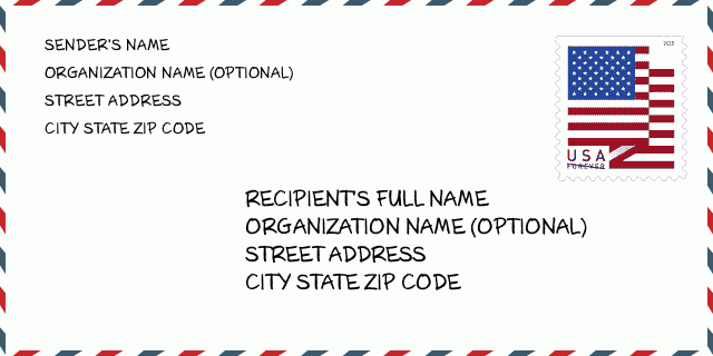
46039-9501 Umschlagbeispiel

-
Dies ist ein Beispiel für einen US-Umschlag. Geben Sie oben links die Informationen des Absenders und unten rechts die Informationen des Empfängers ein. Die erforderlichen Informationen sind der vollständige Name des Absenders/Empfängers, die Anschrift, der Ort, das Bundesland und die Postleitzahl. Die Adressdaten des Empfängers wurden zu Ihrer Information angegeben. Im Allgemeinen gilt: Wenn Sie sich bei der vollständigen 9-stelligen Postleitzahl nicht sicher sind, können Sie nur die 5-stellige Postleitzahl eingeben, um einen Paketverlust zu vermeiden.
46039-9501 Grundlegende Bedeutung
-
Wofür steht jede Ziffer der Postleitzahl 46039-9501? Die Postleitzahl+4 besteht aus zwei Teilen, wobei die ersten fünf Ziffern die Poststelle angeben und die letzten vier Ziffern ein geografisches Segment innerhalb des fünfstelligen Zustellgebiets identifizieren können. Die Ziffern 6-7 bezeichnen einen Sektor oder mehrere Blöcke und die Ziffern 8-9 bezeichnen ein Segment oder eine Straßenseite.
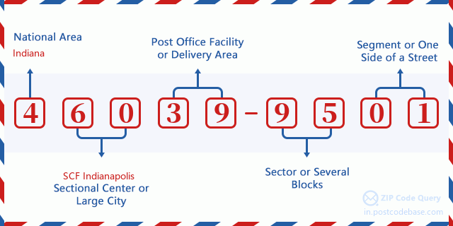

- ·Transportwege-ID?
A 4-digit code assigned to a mail delivery or collection route within a 5-digit ZIP Code. The first character of this identification is alphabetical, and the last three are numeric: Bnnn = PO box Hnnn = Highway contract Rnnn = Rural route Cnnn = City delivery Gnnn = General delivery: R061 (Ländliche Route)
- ·ZIP Plus Niederiger Sektor?
The ZIP Add-On Low Sector and the ZIP Add-On Low Segment together form the ZIP Add-On Low Number. The ZIP Add-On Low Number is the last four positions of a ZIP+4 code; the low-end ZIP add-on in a range of codes; the add-on of the first ZIP+4 code in a consecutive series of ZIP+4 codes assigned to the delivery address. For example, most delivery addresses are assigned a single ZIP+4 code. However, large companies may be given a range of ZIP+4 codes that can be used to route mail to specific departments. A range of ZIP+4 codes can also be assigned to a corresponding range of post office boxes, and each box is mapped, one-to-one, with a ZIP+4 code in the range. A single post office box can also be assigned a range of ZIP+4 codes.: 95
- ·ZIP Plus Niederiges Segment?
The ZIP Add-On Low Sector and the ZIP Add-On Low Segment together form the ZIP Add-On Low Number. The ZIP Add-On Low Number is the last four positions of a ZIP+4 code; the low-end ZIP add-on in a range of codes; the add-on of the first ZIP+4 code in a consecutive series of ZIP+4 codes assigned to the delivery address. For example, most delivery addresses are assigned a single ZIP+4 code. However, large companies may be given a range of ZIP+4 codes that can be used to route mail to specific departments. A range of ZIP+4 codes can also be assigned to a corresponding range of post office boxes, and each box is mapped, one-to-one, with a ZIP+4 code in the range. A single post office box can also be assigned a range of ZIP+4 codes.: 01
- ·ZIP Plus Hoher Sektor?
The ZIP Add-On High Sector and the ZIP Add-On High Segment together form the ZIP Add-On High Number, which is the high-end ZIP add-on in a range of codes; the add-on of the last ZIP+4 code in a consecutive series of ZIP+4 codes assigned to the delivery address. Most delivery addresses are assigned a single ZIP+4 code; however, large companies may be given a range of ZIP+4 codes that can be used to route mail to specific departments. A range of ZIP+4 codes can also be assigned to a corresponding range of post office boxes, and each box is mapped, one-to-one, with a ZIP+4 code in the range. A single post office box can also be assigned a range of ZIP+4 codes. (See also ZIP Add-On Code.): 95
- ·ZIP Plus Hohes Segment?
The ZIP Add-On High Sector and the ZIP Add-On High Segment together form the ZIP Add-On High Number, which is the high-end ZIP add-on in a range of codes; the add-on of the last ZIP+4 code in a consecutive series of ZIP+4 codes assigned to the delivery address. Most delivery addresses are assigned a single ZIP+4 code; however, large companies may be given a range of ZIP+4 codes that can be used to route mail to specific departments. A range of ZIP+4 codes can also be assigned to a corresponding range of post office boxes, and each box is mapped, one-to-one, with a ZIP+4 code in the range. A single post office box can also be assigned a range of ZIP+4 codes. (See also ZIP Add-On Code.): 01
- ·Postleitzahl Hinzufügen: 9501
- ·Reichweite?
The range of +4 codes. Summing the +4 Code and the +4 Range will give you the high end of the range of +4 Codes that pertain to this ZIP Code.: 0
- ·Grundlegender Alternativer Code?
Code that specifies whether a record is a base (preferred) or alternate record. Base records (represented as "B") can represent a range of addresses or an individual address, such as a firm record, while alternate records (represented as "A") are individual delivery points. Government deliveries will only be listed on alternate records with the appropriate government building indicator (federal, state, or city) set.: Basis
- ·Finanzkennzahl?
A code assigned to Postal Service facilities (primarily post offices) to collect cost and statistical data and compile revenue and expense data. The state number comprises the first two positions of the finance number.: 172871
- ·Bundeswahlkreisnummer?
A standard value identifying a geographic area within the United States served by a member of the US House of Representatives or Senate. If Army/Air Force (APO) or fleet post office (FPO), this column will be blank. If there is only one member of Congress within a state, the code will be "AL" (at large).: 04
- ·Bevorzugte letzte Zeile Stadtstaatschlüssel?
An index to the City State file that provides the preferred last-line name for this address range.: X12216
Online Map

Das ist Online-Karte der adresse 4600 N (North) COUNTY ROAD 1100 FOREST. Sie können Knopf verwenden, um zu bewegen und vergrößern/ verkleinern. Die Karteninformation dient nur als Referenz.
Adresse: 4600 (From 4600 To 4699) N (North) COUNTY ROAD 1100 E (East), FOREST, IN 46039-9501, USA
Kommentar


Neuen Kommentar schreiben