عنوان: 5700 (From 5700 To 5799) E (East) COUNTY ROAD 875 S (South), CLOVERDALE, IN 46120-8552, USA
ما هو 46120-8552؟ إنه 46120-8552هو 5700 (From 5700 To 5799) E (East) COUNTY ROAD 875 S (South), CLOVERDALE, IN, USA 5 أضاف4 الرمز البريدي. معلومات التفاصيل علي نحو التالي.
46120-8552 معلومات اساسية

-
الرمز البريدي 5 زائد 4:
46120-8552 -
الرمز البريدي 5:
46120 -
بالإضافة إلى 4?85524-digits that are used to identify a geographic segment within the 5-digit delivery area, such as a city block or a group of apartments or an individual high-volume receiver of mail, or any other unit that could use an extra identifier to aid in efficient mail sorting and delivery. This code is the low end of the range of +4 Codes that pertain to this ZIP Code. ZIP+4 Codes associated with nondelivery areas are composed of valid ZIP sector numbers and "ND" for the ZIP segment number, for example 12345-12ND. Non-deliverable areas are areas to which the USPS does not deliver mail, such as vacant lots and land that borders railroad tracks. Mailers should not match an address identified as a nondelivery area. If you absolutely must have numeric characters in the Plus4Code column, you may treat "ND" values as "00" (zero zero).:
-
بلد:
U.S. - الولايات المتحدة -
حالة:
IN - إنديانا -
مقاطعة:
CountyFIPS: 18133 - Putnam County -
مدينة:
CLOVERDALE -
إتجاه الشارع الأمامي:
E (East) -
شارع?COUNTY ROAD 875The official name of a street as assigned by a local governing authority. The Street Name column contains only the street name and does not include directionals (EAST, WEST, etc.) or suffixes (ST, DR, BLVD, etc.). This element may also contain literals, such as PO BOX, GENERAL DELIVERY, USS, PSC, or UNIT. Numeric street names that have numeric components that are four characters (or less) in length at are justified such that the low-order digit of the number is positioned in the fourth position of the street name column. This shift is made so that the numeric street names appear in numeric sequence.:
-
إتجاه الشارع الخلفي?S (South)A geographic direction that precedes the street name. For Example: 472 MAIN ST N Street Pre-Direction Abbreviation = N Spaces = No pre-direction N = North NE = Northeast E = East SE = Southeast S = South SW = Southwest W = West NW = Northwest:
-
نوع السجل?S: شارعAn alphabetic value that identifies the type of data in the record. Record type codes include the following: G = General delivery H = Highrise F = Firm S = Street P = PO box R = Rural route/highway contract:
عنوان

- الرقم المنخفض من العنوان الرئيسي ?
A house, rural route, highway contract box, or post office box number; the numeric or alphanumeric component of an address preceding the street name; the low-end address in a range of addresses. Often referred to as house number.: 5700
- الرقم العالي من العنوان الرئيسي?
A house, rural route, contract box, or Post Office box number. The numeric or alphanumeric component of an address preceding the street name. The high-end address in a range of addresses. Often referred to as house number.: 5799
- رمز فردي من العنوان الرئيسي/رمز زوجي?
Code that identifies the side or sides of a street for which a given address range is applicable. For street, highrise, firm and multi-carrier records, B = Both sides of a street, E = Even side of a street (even-numbered addresses in the range); O = Odd side of a street (odd-numbered addresses in the range). For general delivery, post office box, and rural route/highway contract records, this code will always be "B" (both).: Both of Odd and Even
- ابتدائي نطاق: 5700, 5701, 5702, 5703, 5704, 5705, 5706, 5707, 5708, 5709, 5710, 5711, 5712, 5713, 5714, 5715, 5716, 5717, 5718, 5719, 5720, 5721, 5722, 5723, 5724, 5725, 5726, 5727, 5728, 5729, 5730, 5731, 5732, 5733, 5734, 5735, 5736, 5737, 5738, 5739, 5740, 5741, 5742, 5743, 5744, 5745, 5746, 5747, 5748, 5749, 5750, 5751, 5752, 5753, 5754, 5755, 5756, 5757, 5758, 5759, 5760, 5761, 5762, 5763, 5764, 5765, 5766, 5767, 5768, 5769, 5770, 5771, 5772, 5773, 5774, 5775, 5776, 5777, 5778, 5779, 5780, 5781, 5782, 5783, 5784, 5785, 5786, 5787, 5788, 5789, 5790, 5791, 5792, 5793, 5794, 5795, 5796, 5797, 5798, 5799.
الرجاء النقر فوق "المزيد من أمثلة العنوان" لعرض القائمة بأكملها.
5700 E (East) COUNTY ROAD 875 S (South), CLOVERDALE, IN 46120-8552
5701 E (East) COUNTY ROAD 875 S (South), CLOVERDALE, IN 46120-8552
5702 E (East) COUNTY ROAD 875 S (South), CLOVERDALE, IN 46120-8552
5703 E (East) COUNTY ROAD 875 S (South), CLOVERDALE, IN 46120-8552
5704 E (East) COUNTY ROAD 875 S (South), CLOVERDALE, IN 46120-8552
5705 E (East) COUNTY ROAD 875 S (South), CLOVERDALE, IN 46120-8552
5706 E (East) COUNTY ROAD 875 S (South), CLOVERDALE, IN 46120-8552
5707 E (East) COUNTY ROAD 875 S (South), CLOVERDALE, IN 46120-8552
5708 E (East) COUNTY ROAD 875 S (South), CLOVERDALE, IN 46120-8552
5709 E (East) COUNTY ROAD 875 S (South), CLOVERDALE, IN 46120-8552
5710 E (East) COUNTY ROAD 875 S (South), CLOVERDALE, IN 46120-8552
5711 E (East) COUNTY ROAD 875 S (South), CLOVERDALE, IN 46120-8552
5712 E (East) COUNTY ROAD 875 S (South), CLOVERDALE, IN 46120-8552
5713 E (East) COUNTY ROAD 875 S (South), CLOVERDALE, IN 46120-8552
5714 E (East) COUNTY ROAD 875 S (South), CLOVERDALE, IN 46120-8552
5715 E (East) COUNTY ROAD 875 S (South), CLOVERDALE, IN 46120-8552
5716 E (East) COUNTY ROAD 875 S (South), CLOVERDALE, IN 46120-8552
5717 E (East) COUNTY ROAD 875 S (South), CLOVERDALE, IN 46120-8552
5718 E (East) COUNTY ROAD 875 S (South), CLOVERDALE, IN 46120-8552
5719 E (East) COUNTY ROAD 875 S (South), CLOVERDALE, IN 46120-8552
5720 E (East) COUNTY ROAD 875 S (South), CLOVERDALE, IN 46120-8552
5721 E (East) COUNTY ROAD 875 S (South), CLOVERDALE, IN 46120-8552
5722 E (East) COUNTY ROAD 875 S (South), CLOVERDALE, IN 46120-8552
5723 E (East) COUNTY ROAD 875 S (South), CLOVERDALE, IN 46120-8552
5724 E (East) COUNTY ROAD 875 S (South), CLOVERDALE, IN 46120-8552
5725 E (East) COUNTY ROAD 875 S (South), CLOVERDALE, IN 46120-8552
5726 E (East) COUNTY ROAD 875 S (South), CLOVERDALE, IN 46120-8552
5727 E (East) COUNTY ROAD 875 S (South), CLOVERDALE, IN 46120-8552
5728 E (East) COUNTY ROAD 875 S (South), CLOVERDALE, IN 46120-8552
5729 E (East) COUNTY ROAD 875 S (South), CLOVERDALE, IN 46120-8552
5730 E (East) COUNTY ROAD 875 S (South), CLOVERDALE, IN 46120-8552
5731 E (East) COUNTY ROAD 875 S (South), CLOVERDALE, IN 46120-8552
5732 E (East) COUNTY ROAD 875 S (South), CLOVERDALE, IN 46120-8552
5733 E (East) COUNTY ROAD 875 S (South), CLOVERDALE, IN 46120-8552
5734 E (East) COUNTY ROAD 875 S (South), CLOVERDALE, IN 46120-8552
5735 E (East) COUNTY ROAD 875 S (South), CLOVERDALE, IN 46120-8552
5736 E (East) COUNTY ROAD 875 S (South), CLOVERDALE, IN 46120-8552
5737 E (East) COUNTY ROAD 875 S (South), CLOVERDALE, IN 46120-8552
5738 E (East) COUNTY ROAD 875 S (South), CLOVERDALE, IN 46120-8552
5739 E (East) COUNTY ROAD 875 S (South), CLOVERDALE, IN 46120-8552
5740 E (East) COUNTY ROAD 875 S (South), CLOVERDALE, IN 46120-8552
5741 E (East) COUNTY ROAD 875 S (South), CLOVERDALE, IN 46120-8552
5742 E (East) COUNTY ROAD 875 S (South), CLOVERDALE, IN 46120-8552
5743 E (East) COUNTY ROAD 875 S (South), CLOVERDALE, IN 46120-8552
5744 E (East) COUNTY ROAD 875 S (South), CLOVERDALE, IN 46120-8552
5745 E (East) COUNTY ROAD 875 S (South), CLOVERDALE, IN 46120-8552
5746 E (East) COUNTY ROAD 875 S (South), CLOVERDALE, IN 46120-8552
5747 E (East) COUNTY ROAD 875 S (South), CLOVERDALE, IN 46120-8552
5748 E (East) COUNTY ROAD 875 S (South), CLOVERDALE, IN 46120-8552
5749 E (East) COUNTY ROAD 875 S (South), CLOVERDALE, IN 46120-8552
5750 E (East) COUNTY ROAD 875 S (South), CLOVERDALE, IN 46120-8552
5751 E (East) COUNTY ROAD 875 S (South), CLOVERDALE, IN 46120-8552
5752 E (East) COUNTY ROAD 875 S (South), CLOVERDALE, IN 46120-8552
5753 E (East) COUNTY ROAD 875 S (South), CLOVERDALE, IN 46120-8552
5754 E (East) COUNTY ROAD 875 S (South), CLOVERDALE, IN 46120-8552
5755 E (East) COUNTY ROAD 875 S (South), CLOVERDALE, IN 46120-8552
5756 E (East) COUNTY ROAD 875 S (South), CLOVERDALE, IN 46120-8552
5757 E (East) COUNTY ROAD 875 S (South), CLOVERDALE, IN 46120-8552
5758 E (East) COUNTY ROAD 875 S (South), CLOVERDALE, IN 46120-8552
5759 E (East) COUNTY ROAD 875 S (South), CLOVERDALE, IN 46120-8552
5760 E (East) COUNTY ROAD 875 S (South), CLOVERDALE, IN 46120-8552
5761 E (East) COUNTY ROAD 875 S (South), CLOVERDALE, IN 46120-8552
5762 E (East) COUNTY ROAD 875 S (South), CLOVERDALE, IN 46120-8552
5763 E (East) COUNTY ROAD 875 S (South), CLOVERDALE, IN 46120-8552
5764 E (East) COUNTY ROAD 875 S (South), CLOVERDALE, IN 46120-8552
5765 E (East) COUNTY ROAD 875 S (South), CLOVERDALE, IN 46120-8552
5766 E (East) COUNTY ROAD 875 S (South), CLOVERDALE, IN 46120-8552
5767 E (East) COUNTY ROAD 875 S (South), CLOVERDALE, IN 46120-8552
5768 E (East) COUNTY ROAD 875 S (South), CLOVERDALE, IN 46120-8552
5769 E (East) COUNTY ROAD 875 S (South), CLOVERDALE, IN 46120-8552
5770 E (East) COUNTY ROAD 875 S (South), CLOVERDALE, IN 46120-8552
5771 E (East) COUNTY ROAD 875 S (South), CLOVERDALE, IN 46120-8552
5772 E (East) COUNTY ROAD 875 S (South), CLOVERDALE, IN 46120-8552
5773 E (East) COUNTY ROAD 875 S (South), CLOVERDALE, IN 46120-8552
5774 E (East) COUNTY ROAD 875 S (South), CLOVERDALE, IN 46120-8552
5775 E (East) COUNTY ROAD 875 S (South), CLOVERDALE, IN 46120-8552
5776 E (East) COUNTY ROAD 875 S (South), CLOVERDALE, IN 46120-8552
5777 E (East) COUNTY ROAD 875 S (South), CLOVERDALE, IN 46120-8552
5778 E (East) COUNTY ROAD 875 S (South), CLOVERDALE, IN 46120-8552
5779 E (East) COUNTY ROAD 875 S (South), CLOVERDALE, IN 46120-8552
5780 E (East) COUNTY ROAD 875 S (South), CLOVERDALE, IN 46120-8552
5781 E (East) COUNTY ROAD 875 S (South), CLOVERDALE, IN 46120-8552
5782 E (East) COUNTY ROAD 875 S (South), CLOVERDALE, IN 46120-8552
5783 E (East) COUNTY ROAD 875 S (South), CLOVERDALE, IN 46120-8552
5784 E (East) COUNTY ROAD 875 S (South), CLOVERDALE, IN 46120-8552
5785 E (East) COUNTY ROAD 875 S (South), CLOVERDALE, IN 46120-8552
5786 E (East) COUNTY ROAD 875 S (South), CLOVERDALE, IN 46120-8552
5787 E (East) COUNTY ROAD 875 S (South), CLOVERDALE, IN 46120-8552
5788 E (East) COUNTY ROAD 875 S (South), CLOVERDALE, IN 46120-8552
5789 E (East) COUNTY ROAD 875 S (South), CLOVERDALE, IN 46120-8552
5790 E (East) COUNTY ROAD 875 S (South), CLOVERDALE, IN 46120-8552
5791 E (East) COUNTY ROAD 875 S (South), CLOVERDALE, IN 46120-8552
5792 E (East) COUNTY ROAD 875 S (South), CLOVERDALE, IN 46120-8552
5793 E (East) COUNTY ROAD 875 S (South), CLOVERDALE, IN 46120-8552
5794 E (East) COUNTY ROAD 875 S (South), CLOVERDALE, IN 46120-8552
5795 E (East) COUNTY ROAD 875 S (South), CLOVERDALE, IN 46120-8552
5796 E (East) COUNTY ROAD 875 S (South), CLOVERDALE, IN 46120-8552
5797 E (East) COUNTY ROAD 875 S (South), CLOVERDALE, IN 46120-8552
5798 E (East) COUNTY ROAD 875 S (South), CLOVERDALE, IN 46120-8552
5799 E (East) COUNTY ROAD 875 S (South), CLOVERDALE, IN 46120-8552
عنوان مثال
CLOVERDALE IN 46120-8552
UNITED STATES OF AMERICA
46120-8552 مثال المغلف

-
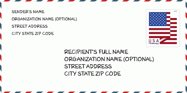
هذا مثال على مغلف الولايات المتحدة. املأ معلومات المرسل في أعلى اليسار ومعلومات المستلم في أسفل اليمين. المعلومات الضرورية هي الاسم الكامل للمرسل / المستلم وعنوان الشارع والمدينة والولاية والرمز البريدي. تم تقديم معلومات عنوان المستلم كمرجع لك. بشكل عام ، إذا لم تكن متأكدًا من الرمز البريدي الكامل المكون من 9 أرقام ، فيمكنك فقط ملء الرمز البريدي المكون من 5 أرقام لتجنب فقد الحزمة.
46120-8552 المعنى الأساسي
-
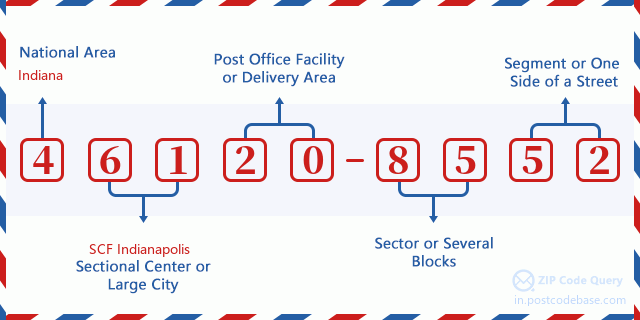
ما الذي يرمز إليه كل رقم في الرمز البريدي 46120-8552؟ يتكون الرمز البريدي + 4 من جزأين ، يمكن تحديد موقع أول خمسة أرقام في مكتب البريد ، ويمكن للأرقام الأربعة الأخيرة تحديد مقطع جغرافي داخل منطقة التسليم المكونة من خمسة أرقام. تحدد الأرقام المكونة من 6 إلى 7 أرقام قطاعًا أو عدة كتل ، بينما تحدد الأرقام المكونة من 8 إلى 9 أرقام مقطعًا أو جانبًا واحدًا من الشارع.

- ·طرق النقل ID?
A 4-digit code assigned to a mail delivery or collection route within a 5-digit ZIP Code. The first character of this identification is alphabetical, and the last three are numeric: Bnnn = PO box Hnnn = Highway contract Rnnn = Rural route Cnnn = City delivery Gnnn = General delivery: R002 (المسار الريفية)
- ·أضاف البريد علي قطاع منخفضة?
The ZIP Add-On Low Sector and the ZIP Add-On Low Segment together form the ZIP Add-On Low Number. The ZIP Add-On Low Number is the last four positions of a ZIP+4 code; the low-end ZIP add-on in a range of codes; the add-on of the first ZIP+4 code in a consecutive series of ZIP+4 codes assigned to the delivery address. For example, most delivery addresses are assigned a single ZIP+4 code. However, large companies may be given a range of ZIP+4 codes that can be used to route mail to specific departments. A range of ZIP+4 codes can also be assigned to a corresponding range of post office boxes, and each box is mapped, one-to-one, with a ZIP+4 code in the range. A single post office box can also be assigned a range of ZIP+4 codes.: 85
- ·أضاف البريد علي جزء منخفضة?
The ZIP Add-On Low Sector and the ZIP Add-On Low Segment together form the ZIP Add-On Low Number. The ZIP Add-On Low Number is the last four positions of a ZIP+4 code; the low-end ZIP add-on in a range of codes; the add-on of the first ZIP+4 code in a consecutive series of ZIP+4 codes assigned to the delivery address. For example, most delivery addresses are assigned a single ZIP+4 code. However, large companies may be given a range of ZIP+4 codes that can be used to route mail to specific departments. A range of ZIP+4 codes can also be assigned to a corresponding range of post office boxes, and each box is mapped, one-to-one, with a ZIP+4 code in the range. A single post office box can also be assigned a range of ZIP+4 codes.: 52
- ·أضاف البريد علي قطاع عالية?
The ZIP Add-On High Sector and the ZIP Add-On High Segment together form the ZIP Add-On High Number, which is the high-end ZIP add-on in a range of codes; the add-on of the last ZIP+4 code in a consecutive series of ZIP+4 codes assigned to the delivery address. Most delivery addresses are assigned a single ZIP+4 code; however, large companies may be given a range of ZIP+4 codes that can be used to route mail to specific departments. A range of ZIP+4 codes can also be assigned to a corresponding range of post office boxes, and each box is mapped, one-to-one, with a ZIP+4 code in the range. A single post office box can also be assigned a range of ZIP+4 codes. (See also ZIP Add-On Code.): 85
- ·أضاف البريد علي جزء عالية?
The ZIP Add-On High Sector and the ZIP Add-On High Segment together form the ZIP Add-On High Number, which is the high-end ZIP add-on in a range of codes; the add-on of the last ZIP+4 code in a consecutive series of ZIP+4 codes assigned to the delivery address. Most delivery addresses are assigned a single ZIP+4 code; however, large companies may be given a range of ZIP+4 codes that can be used to route mail to specific departments. A range of ZIP+4 codes can also be assigned to a corresponding range of post office boxes, and each box is mapped, one-to-one, with a ZIP+4 code in the range. A single post office box can also be assigned a range of ZIP+4 codes. (See also ZIP Add-On Code.): 52
- ·الرمز البريدي ملحق: 8552
- ·نطاق?
The range of +4 codes. Summing the +4 Code and the +4 Range will give you the high end of the range of +4 Codes that pertain to this ZIP Code.: 0
- ·رمز البديل الأساسي?
Code that specifies whether a record is a base (preferred) or alternate record. Base records (represented as "B") can represent a range of addresses or an individual address, such as a firm record, while alternate records (represented as "A") are individual delivery points. Government deliveries will only be listed on alternate records with the appropriate government building indicator (federal, state, or city) set.: قاعدة
- ·الأرقام المالية?
A code assigned to Postal Service facilities (primarily post offices) to collect cost and statistical data and compile revenue and expense data. The state number comprises the first two positions of the finance number.: 171672
- ·رقم منطقة الكونغرس?
A standard value identifying a geographic area within the United States served by a member of the US House of Representatives or Senate. If Army/Air Force (APO) or fleet post office (FPO), this column will be blank. If there is only one member of Congress within a state, the code will be "AL" (at large).: 04
- ·رمز المدينة المفضلة الأخير?
An index to the City State file that provides the preferred last-line name for this address range.: X11882
خريطة الانترنت

هذا هو عنوان 5700 E (East) COUNTY ROAD 875 CLOVERDALE مطابقة الخريطة الإلكترونية عبر الإنترنت يمكنك استخدام زر في الخريطة للتحرك وتكبير. معلومات الخريطة هي للإشارة فقط.
عنوان: 5700 (From 5700 To 5799) E (East) COUNTY ROAD 875 S (South), CLOVERDALE, IN 46120-8552, USA
التعليق


إضافة تعليق جديد